About us
Books and letters
Calendar
Contact
Evaluation Committee
Events
Publishing Guide
Reporting Geo-sp
Submit new event
Titles of published researches
English
Français
العربية
Home
About us
Evaluation Committee
Publishing Guide
Research
Interviews
Events
Books and letters
Books
Contact
Sort
Recent
Most Commented
Random
Published Researches
Evaluation of ground water potential zones of nakkavagu catchment in hyderabad, andhra pradesh, India by using Remote sensing and Gis Technique.
by Ali Neji
0
Full Review »
Published Researches
Environmental impacts of brick factories in Iraq
by Ali Neji
0
Full Review »
Published Researches
Use of Space Technologies and GIS to Study Groundwater Potential Zones in the Western Coast of the Kingdom of Saudi Arabia
by Ali Neji
0
Full Review »
Published Researches
Development of Water Resources in Koya City, Iraq
by Ali Neji
0
Full Review »
Published Researches
DETECTIONS OF BUILDINGSDIGITAL SURFACE MODELS DEFORMATIONS GENERATED FROM DRONES NADIR IMAGES
DETECTIONS OF BUILDINGSDIGITAL SURFACE MODELS DEFORMATIONS GENERATED FROM DRONES NADIR IMAGES Jean A. Doumit*, Souhail F. Awad*,Evgeny N. Kiselev** *Lebanese University, Faculty of Letters and Human Sciences, Department of g...
by Lamouchi Helmi
0
Full Story »
Published Researches
Improve Of Health care Systems for Smart Hospitals Based on UML and Semantic Web Technology
by Ali Neji
0
Full Review »
Published Researches
Determine The Regression of Agricultural areas by using Landsat images for mid Euphrates – Iraq
by Ali Neji
0
Full Review »
Published Researches
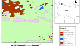
Soil Productivity Rating Index Model Using Geographic Information System in Libya
by Ali Neji
0
Full Review »
Published Researches
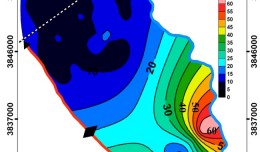
Application of Vertical Electrical Sounding to Delineate and Evaluate the Hydrological Conditions in Baiji –Tikrit Basin
by Ali Neji
0
Full Review »
Page 7 of 8
« First
‹ Previous
4
5
6
7
8
Next ›
The Latest
News
Articles and Interviews
Reporting Geo-sp
Published Researches
Precision Technologies Role in the Study of Climate Change Impact
5th International Conference on Water, Energy, Food and Agricultural Technology Istanbul, Turkey, 22-25 January 2019
10th edition of the International Congress & technologies dedicated to geospatial applications
Bluesky’s LiDAR experts educate Mouchel’s water industry professionals
Creation of a digital 3-dimensional model
AeroMetric Announces New High Accuracy Mapping Solution
Interview with George Gartner
Measuring earth’s vital magnetic field
Determine the morphostructure phenomenon, East Khor Al-Zubair by Space Imageries
Detection and monitoring crop of wheat and barley by using NDVI stacking technique and spectral angle mapper algorithm
Tunisian economy in the face of the Covid-19 pandemic: State of play, analysis and outlook
More »
More »
More »
More »
 English
  Français
  العربية