Articles and Interviews

6 May 2013

History in 3D

Time travel to the past or to the future has always been the dream of humanity. We have always imagined life in the past or the future, but what would it be like if we walked around in the city Paris of 2000 years ago though a simple click on Ipad.

In fact, it is no longer a dream, Dassault Systèmes, specialized in software; offers product developers the opportunity to experience their products digitally, before making them physically, developed a new 3D experience that allows accurate digital recreation of Paris: buildings, thermal baths and the Bastille.

The city of Paris has been digitized, now its 2000 years history can be discovered through iPad, or internet, which makes the distinction between reality and simulation almost impossible.

To reach such a result, specialists have been working for several years on digitizing and modeling historical data. Specialists have been able to model and texture architectural drawings, oil paintings and documents using 3DExperience software. Elements of the 3DExperience platform simulate weather effects, geographical, architectural environments, and realistic lighting while the company’s animation engine technology brings the models to life.

Concerning the buildings that no longer exist and that cannot be scanned, the team used the emerging 3D digital models to test and examine hypotheses and then make final decisions.

Paris 3D Saga

Showing a precise picture of the Bastille was an important element of the project, since the paintings of the Bastille show just a massive towering over the Paris and its revolutionary inhabitants. Whereas 3D modeling presents an accurate picture of the Bastille which is, by the way, smaller than what was imagined.

The Ipad app, Paris 3D Saga, gives the user the opportunity to compare the past and the present or the realty and the reality-like, 3D Paris of 2000 years ago. The app does also contain 3D films and a series of documentary films about digitized Paris, also developed by Dassault Systèmes.

Giza Plateau

Is another app similar the Paris 3D saga, developed by Dassault Systèmes and Harvard University, but this time the app takes you to ancient Egypt.

Giza, which is situated in the periphery of Cairo, is built by ancient Egyptians, who manifested their civilization, architecture, art and their conception of afterlife in the cities and monuments they built. The Giza 3D project is a manner of preserving this heritage and bringing to life the heritage which was already lost.

The biggest city in Africa, Giza was reconstructed and digitalized by Dassault Systèmes through the material that was available; diaries, drawings and documents, most of them were collected or developed by the American archeologist George Reisner, in order to reach the most accurate results.

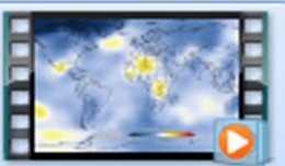
Other than Paris and Giza apps, Dassault Systèmes is working with on major cities of the world.  Dassault Systèmes has created partnerships with water conservation, city planning, energy and waste management companies. The partnership is about Dassault Systèmes Company’s stimulation of the present situation which will generate the picture of city 30 years from now. Thanks to this technology, the world can see the impact of any decision on our planet. This technology can also show the effects of natural disasters and can assist in better planning which will bring betters results.  Nick Lerner says “Using 3D laser scanning and modelling techniques, archaeologists have been able to recreate buildings from ancient Paris and Egypt. But the technology can also be used in planning for the future”


1595_481137111962333_1750011374_n

Bluesky’s LiDAR experts educate Mouchel’s water industry professionals

The Mouchel Urban Drainage Academy (MUDA) trains water industry professionals Aerial mapping company Bluesky is helping water industry professionals understand the potential of laser captured height models. Following a request ...
by Lamouchi Helmi
0


Pict1_working meeting

Creation of a digital 3-dimensional model

TogliattiKauchuk Plant – Togliatti, Russia  Laser scanning as a method of storage of spatial information is used in various economic sectors. In this article, we will focus on laser scanning for industrial design, or more pr...
by Lamouchi Helmi
0


p3-gulfstream

AeroMetric Announces New High Accuracy Mapping Solution

Sheboygan, Wisconsin, May 23, 2013 – AeroMetric announced the addition of a new High Accuracy Mapping Solution for its clients. The new solution is designed to obtain tight vertical accuracy and highly detailed imagery...
by Lamouchi Helmi
0


téléchargement

Learn to Use Esri’s Collector for ArcGIS on Your Smartphone

You can work with maps in the field using Esri’s Collector for ArcGIS app on your iPhone or Android smartphone. You can also use maps to capture spatial and tabular data with the phone’s GPS or by tapping on the map...
by Lamouchi Helmi
0


VV02 retrait portique

ESA’S VEGA LAUNCHER SCORES NEW SUCCESS WITH PROBA-V

The second flight of ESA’s newest launch vehicle has been completed from Europe’s Spaceport in Kourou, French Guiana. Two Earth observation satellites, ESA’s Proba-V and Vietnam’s VNREDSat‑1A, were released into diffe...
by Lamouchi Helmi
0


19860728

New Public Application of Landsat Images Released

Google released more than a quarter-century of images of Earth taken from space Thursday compiled into an interactive time-lapse experience. Working with data from the Landsat Program managed by the U.S. Geological Survey, the ...
by Lamouchi Helmi
0


746080main1_Graham_latest_226

NASA and Amateur Radio Operators Piece Together the PhoneSat Picture

Although the ultimate goal of the PhoneSat mission was to determine whether a consumer-grade smartphone can be used as the main flight avionics for a satellite in space, the three miniature satellites (named Alexander, Graham a...
by Lamouchi Helmi
0


1367507172iPad5

Google Maps for iPad Has Mileage with Latest EggMaps Update

PERTH, Australia, May 6, 2013 — (PRNewswire) —  Mike Cunneen today announces EggMaps HD 1.05, an update to his popular #1-ranked navigation app for iPad that provides Google Maps at full-screen high resolution. Version 1....
by Lamouchi Helmi
0


images

PCI Geomatics Software Supports KOMPSAT-3 Sensor

RICHMOND HILL, Ontario, Canada, May 03, 2013 – PCI Geomatics, a world-leading developer of remote sensing and photogrammetric software and systems, announced today that it now supports KOMPSAT-3 imagery within its softwa...
by Lamouchi Helmi
0


DSC_01551

Minister of communication and Information Technologies opens the activities of the 7th edition of Geotunis

Dr. Monji Marzouk, Minister of communication and Information Technologies opened on Monday, April 8 2013 the activities of the 7th edition of the international congress geotunis held under the slogan: Through geographic infrast...
by Lamouchi Helmi
0


Untitled-2

NASA Finds 2012 Sustained Long-Term Climate Warming Trend

NASA scientists say 2012 was the ninth warmest of any year since 1880, continuing a long-term trend of rising global temperatures. With the exception of 1998, the nine warmest years in the 132-year record all have occurred sinc...
by Lamouchi Helmi
0


Alphasat_1-XL_large

Alphabus/Alphasat

ARTES 8 Alphabus/Alphasat is dedicated to the development and deployment of the Alphasat satellite. Alphasat is being built in partnership between ESA and European operator Inmarsat by Astrium. It is the first satellite to us...
by Lamouchi Helmi
0


0 comments »


Be the first to comment!


Leave a Reply

Your email address will not be published. Required fields are marked *

*

* Copy This Password *

* Type Or Paste Password Here *

You may use these HTML tags and attributes: <a href="" title=""> <abbr title=""> <acronym title=""> <b> <blockquote cite=""> <cite> <code> <del datetime=""> <em> <i> <q cite=""> <strike> <strong>