Articles and Interviews

10 May 2013

New Public Application of Landsat Images Released

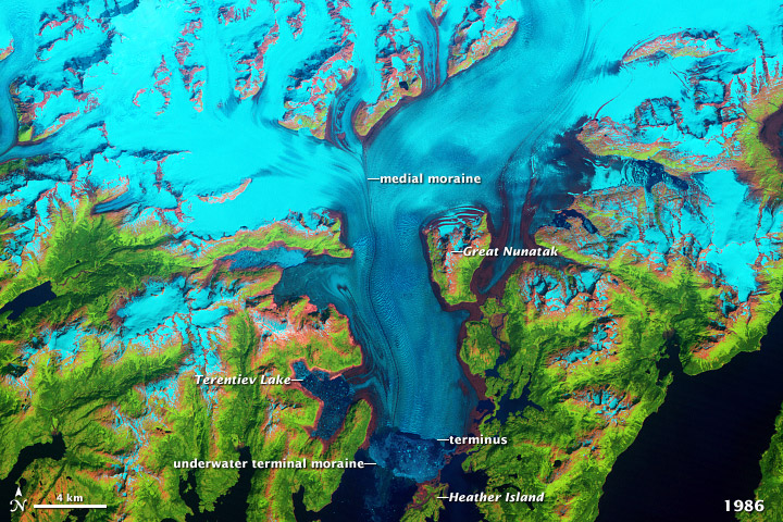
Google released more than a quarter-century of images of Earth taken from space Thursday compiled into an interactive time-lapse experience. Working with data from the Landsat Program managed by the U.S. Geological Survey, the images display an historical perspective on changes to Earth’s surface over time.

                                             The decline of Alaska’s Columbia Glacier is one

                                                                      of the Earthchanges featured in the new Google

                                                                           imagery based on the Landsat data archive.

                                                                                     › More on Columbia Glacier

NASA Associate Administrator for Communications David Weaver issued the following statement about the Google announcement:

“The Landsat data record — humanity’s longest continuous record of our planet from space — has been an invaluable tool for scientists and decision-makers in many fields, from natural resources to agricultural productivity and climate change. The release today on Google’s Earth Engine of new Landsat time-lapse data animations shows key changes across our planet and helps share this remarkable U.S. resource with the public in an engaging new way.

“The Obama administration is committed to keeping this freely accessible archive of continuous global land observations growing for years to come. That’s why the president’s Fiscal Year 2014 budget includes funding to have NASA take the lead on the design of a new spaceborne system that will continue the acquisition of Landsat-quality measurements.

“NASA launched the newest Landsat satellite in February. Later this month, we will be handing over operations of this mission to our long-time partners at the U.S. Geological Survey. NASA is looking forward to beginning the work to extending this critically important national resource.”

Related Links

› More information about the new Google images
› NASA Landsat website
› USGS Landsat website

Steve Cole
NASA Headquarters


2

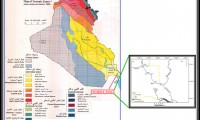
Determine the morphostructure phenomenon, East Khor Al-Zubair by Space Imageries

Dr.TorhanAlmofti *                                         Ahmed Ibrahim Saleh Al-Naemi** Abstract Through the use of satellite data taken by the Landsat satellites a color phenomenon was...
by Lamouchi Helmi
0


1

Detection and monitoring crop of wheat and barley by using NDVI stacking technique and spectral angle mapper algorithm

S K AAl-Hummadi[1] N S Nuaimy[2] A L Ubaidy[3] 1Ministry of science and Technology, ,Remote sensing center, Iraq E-mail: shathamaster@yahoo.com   2Ministry of science and Technology, Remote sensing center, Iraq E-mail: ade...
by Lamouchi Helmi
0


2

Tunisian economy in the face of the Covid-19 pandemic: State of play, analysis and outlook

Bouzayani Rajab [1]/ Abida Zouheir[2] [1] Bouzayani Rajab : Faculty of Economics and Management of Sfax, University of Sfax – Tunisia. E-mail: bouzayanilazher@gmail.com [2] Abida Zouheir : Faculty of Economics and Mana...
by Lamouchi Helmi
0


Thumbnail.8.640.360

Reducing Total Freshwater Use in the Gold Processing Industry Using Linear Programming

Suliman Emdini Gliwan*1 Kevin Crowe *2 *1Ph.D.Candidate, Faculty of Natural Resource Management, Lakehead University, 955 Oliver Rd, Thunder Bay, ON, Canada (P7B5E1). *2Associate Professor, Faculty of Natural Resource Managemen...
by Lamouchi Helmi
0


06-731x413

Control of a Hybrid Wind-PV and Energy Storage System

Control of a Hybrid Wind-PV and Energy Storage System Mohammed Al Busaidi, Amer Al-Hinai*, Rashid Al-Abri, Mohammed Al-Badi Electrical & Computer Engineering, Sultan Qaboos University, Oman Abstract—Distributed energy gen...
by Lamouchi Helmi
0


images

Modeling Ripeness Grading of Palm Oil Fresh Fruit Bunches through Image Processing using Artificial Neural Network

Modeling Ripeness Grading of Palm Oil Fresh Fruit Bunches through Image Processing using Artificial Neural Network Osama M. Ben Saaed1, Meftah Salem M Alfatni1,2*, Abdul Rashid Mohamed Shariff3 and Hadya S Hawedi1 1Faculty of I...
by Lamouchi Helmi
0


maxresdefault

DETECTIONS OF BUILDINGSDIGITAL SURFACE MODELS DEFORMATIONS GENERATED FROM DRONES NADIR IMAGES

  DETECTIONS OF BUILDINGSDIGITAL SURFACE MODELS DEFORMATIONS GENERATED FROM DRONES NADIR IMAGES Jean A. Doumit*, Souhail F. Awad*,Evgeny N. Kiselev** *Lebanese University, Faculty of Letters and Human Sciences, Department of g...
by Lamouchi Helmi
0


Prezentacja programu PowerPoint

Comparative responses to cadmium toxicity of Arabidopsis thaliana mutant seedling (cad2) and wild type (col0)

Comparative responses to cadmium toxicity of Arabidopsis thaliana mutant seedling (cad2) and wild type (col0) CHAFFEI HAOUARI CHIRAZ1, SLATNI TARAK2, DJEMAL FATMA1, GOUIA HOUDA1 (Company / Faculté des Sciences de Tunis) 1Unive...
by Lamouchi Helmi
0


1320_effects-image

Precision Technologies Role in the Study of Climate Change Impact

The Second session of the International Symposium Precision Technologies Role in the Study of Climate Change Impact and its implications on the Economic and Natural Structure: The reality and suggested solutions Istanbul, Turke...
by Lamouchi Helmi
0


f0ecbd2a-2ed9-458d-91ab-07e1caedea10-9867cc4df536.small

5th International Conference on Water, Energy, Food and Agricultural Technology Istanbul, Turkey, 22-25 January 2019

5th International Conference on Water, Energy, Food and Agricultural Technology Istanbul, Turkey, 22-25 January 2019   Scientific themes 1-      water resources and desertification and agricultural techniques 2-   ...
by Lamouchi Helmi
0


wwwwww

Drone base multiscale Digital Surface Models to planar areas.

Drone base multiscale Digital Surface Models to planar areas. Dr. Jean A. Doumit   Abstract The obtaining of a Digital Surface models (DSMs) at different scales and levels before the appearance of Unmanned Aerial Vehicles (UAV...
by Lamouchi Helmi
0


1

Monitoring of Mosul Reservoir Using Remote Sensing TechniquesFor the Period After ISIS Attack in 9 June 2014

Monitoring of Mosul Reservoir Using Remote Sensing TechniquesFor the Period After ISIS Attack in 9 June 2014 Lecture:  Muthanna Mohammed Abdulhameed AL Bayati University of Technology – Baghdad- Building and Construction Dep...
by Lamouchi Helmi
0


0 comments »


Be the first to comment!


Leave a Reply

Your email address will not be published. Required fields are marked *

*

* Copy This Password *

* Type Or Paste Password Here *

You may use these HTML tags and attributes: <a href="" title=""> <abbr title=""> <acronym title=""> <b> <blockquote cite=""> <cite> <code> <del datetime=""> <em> <i> <q cite=""> <strike> <strong>