English
  Français
  العربية

ملخص

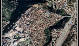
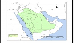
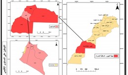
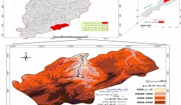
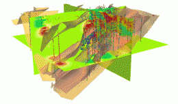
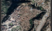
تم دراسة منطقة كمدة في وادي الدواسر في المملكة العربية السعودية باستخدام تقنيات الأستشعار عن بعد و نظم المعلومات الجغرافية (GIS)، وذلك من خلال ترقيم الطرق الرئيسية والفرعية وترقيم خطوط الكنتور ومجاري الأودية، بالإضافة إلى ترقيم النشاط الزراعي في المنطقة بمختلف أنواعه كزراعة النخيل والمحاصيل الموسمية والمناطق الزراعية المختلفة، وترقيم الوحدات الجيولوجية لمنطقة الدراسة. وذلك من خلال الاعتماد على خريطة طبوغرافية بمقياس رسم 1:50000 وخريطة جيولوجية بمقياس رسم 1:500000 ومرئية فضائية (SPOT). كذلك تم بناء قاعدة بيانات جغرافية لمنطقة الدراسة (Geodatabase)، كما تم إدراج طبقات مختلفة في قاعدة البيانات مثل الطبقات الخطية: كخطوط الكنتور Contours، ومجاري الأودية Wadies ، وشبكة الطرق Road Network. والطبقات المساحية مثل: الوحدات الجيولوجية Geological Units، والأراضي المزروعة Agricultural Areas . والطبقات النقطية مثل: نقاط الارتفاع High Points. كذلك تم إضافة معلومات الطبقات Annotation مثل: أسماء الأماكن Names Local، وأسماء الوحدات الجيولوجية Geologic Units. وتم الاعتماد على برنامج ArcMap إحد برامج ArcGIS من إنتاج شركة ESRI المتخصصة في إنتاج برامج وأدوات نظم المعلومات الجغرافية في تحرير وترقيم الطبقات المختلفة في هذه الدراسة. كما تم استخدام برنامج ArcScene في الإخراج النهائي للمشروع بالأبعاد الثلاثية (DEM).
وقد أكدت نتائج الدراسة على أن الخريطة لم تعد وعاء لمعلومة ثابتة بل أصبحت ساحة لرؤية المعلومة من زوايا إحصائية أو تحليلية مختلفة وبعرض للنتائج على خرائط موضوعية مختلفة تمكن المستخدم من رؤية الظواهر الجغرافية في شكل رقمي يمكن المستخدم من رؤية الظاهرة الجغرافية من أي زاوية مختارة وبأي طريقة علمية تصنيفية مناسبة تساعد على عرض النتائج التي توصلت إليها الدراسات بشكل واضح يمكن من بيان الحقيقة المدعمة تقنياً والمساعدة في صنع وأتخاذ القرار الصحيح.
الكاتب
د. إياد حكم فضة* د. ناصر مرشد الزير *عبد الله محمد المثيبي
EYAD H. R. FADDA
Qualifications
2003 PhD. Geomatics Engineering (GIS and Remote Sensing) in Geohazards, University of Dundee, UK. 1991 M.Sc. Remote Sensing, Image Processing and Applications, University of London, U.K. 1990 Diploma in Remote Sensing, University College of London, U.K. 1985 B.Sc. Earth and Environmental Sciences, Yarmouk University, Jordan. Language ability English: Excellent (British Universities Graduate). Further abilities International Computer Driving Licence (ICDL): in English.Effective Tertiary Teaching: Certificate of recognition for completion of New York Institute of Technology’s professional development program. Memberships 1997 Member of Mediterranean Arid Regions Observatory Group, EARSEL, European Commission. 1996 Member of Mediterranean Data Fusion Group, EARSEL, European Commission. 1989 Member of Remote Sensing Society, Nottingham. 1985 Member of Jordanian Geologists Association Awards/Merits 1997 Selected to receive one of the prestigious 1997/98 Hubert H. Humphrey Awards (Fullbright) in the USA. The Hubert H. Humphrey grants are awarded based on the proven professional excellence of the candidate. 1995 Visiting Scientist, University of Dundee, Scotland, U.K.Experience
2009 - Now: Assistant Professor
Dept. of Geography, Faculty of Art, King Saud University Riyadh, 11451, B.O. Box 2456 Saudi Arabia.2000 - 2009: Assistant Professor / Geomatics Engineering
Dean Assistant / Faculty of Engineering
Dept. of Surveying and Geomatics Engineering Faculty of Engineering, Al-Balqa Applied University, Al-Salt, Jordan. Assistant Professor / Remote Sensing, Digital image Processing, GIS, Geospatial Modelling and Geosciences.1999 -2000: Lecturer, Remote Sensing & GIS
Department of Earth and Environmental Sciences, Institute of Lands, Water and Environment, Hashemite University, Jordan.1997 – 1999: Lecturer, Remote Sensing and GIS
Department of Geology, United Arab Emirates University. United Arab Emirates.1994 - 1995: Visiting Scientist
Remote Sensing Group,
University of Dundee,
Scotland, U.K.
- Working in the Remote Sensing Group of the Department of Applied
1985 -1997: Senior Geologist
Natural Resources Authority, Ministry of Energy and Mineral Resources, Jordan. Publications- 1. Fadda, E. H., Taghrid M. H. Dmour, 2009. Using GIS, Remote Sensing and Associated Digital Image Processing Techniques to produce Land Use Capability Map for Zarqa area, Jordan. The International Conference on Information Technology (ICIT’2009), IEEE PUBLICATION TITLE (Journal, Magazine, Conference, Book): ISBN: 9957-8583-0-0, ICIT, held at Al-Zaytoonah University, Jordan on June 3-5, 2009.
- 2. Fadda, E. H., Maher Kakish and Tariq Al Azab, 2009. The implementation of Satellite images and associated digital image processing in addition to GIS modeling for urban mapping in Amman area, Jordan. Issue 2, Volume 8, 2009, pp. 300-309. ISSN: 1109-2742. Published by Wseas; transactions on communications.
- 3. Fadda, E. H., Maher Kakish and Akkawi E., 2008. Relational GIS and Remote Sensing Database System for Al-salt area, Jordan. International Journal of Engineering and Applied Science, Volume 1, No, 4: 241-247, 2008. ISSN 1941-7020. Published by science Publications. USA.
- 4. Maher Kakish, Fadda, E. H. Akkawi E., 2008. Design of T-Beam Bridge by Finite Element Method and Aashot Specification. KMITL Science Journal Volume 8, No, 1, pp 24-34 January-June, 2008.
- 5. Fadda, E. H. and Maher Kakish 2008. The use of remote sensing and digital image processing techniques for geo-environmental mapping; visual and statistical analysis. International Journal of Applied Science and Computations, Volume 15, No, 2 2008. ISSN 1089-0025. Published by Institute of applied science and Computations, Charlestone, IIIinois USA.
- 6. Fadda, E. H., 2007. The use of Geomatics engineering for geological hazards mapping in Salt area, Jordan. International Journal of Applied Science and Computations, Volume 14, No, 3 December 2007, pp. 143-154. ISSN 1089-0025. Published by Institute of applied science and Computations, Charlestone, IIIinois USA.
- 7. Fadda, E. H. and Al-Hanbali, N., 2007. Implementing of GIS and digital image processing techniques for structural mapping in Salt area, Jordan. Map Middle East 2007 is the 3rd Annual Middle East Conference and Exhibition on Geospatial Information, Technology and Applications with a theme of Geospatial for all - All for Geospatial. April 9-11, 2007 in Dubai International Convention and Exhibition Centre World Trade Center, Dubai,UAE.
- 8. Al-Hanbali, N. N., Fadda, E. H., Kassab, A., Ayesh, M., Smadi, R., 2007. "Geospatial Information Modeling and Implementation for Navigation, Tracking and Address Location Services in Jordan", The Second national GIS Symposium in Saudi Arabia, Dammam, April 23-25, 2007.
- 9. Al-Hanbali, N. N., Fadda, E. H., Rawashdeh, S. 2006. “Building 3D GIS Modeling Applications in Jordan: Methodology and Implementation Aspects”, Innovation in 3D Geo Information Systems, ٍSpringer –Verlag Berlin Heidlberg 2006, Editors: Alias Abdul-Rahman, Sisi Zlatanova and Volker Coors (Eds.), ISBN 10 3-540-36997-x Springer Berlin Heidelberg New York.
- 10. Al-Hanbali, N., Fadda, E. H., Awamleh, B., and Al-Durgham, M., 2006. Building 3D GIS Model of a University Campus for Planning Purposes: Methodology and Implementation Aspects. Map Middle East 2006 is the 2nd Annual Middle East Conference and Exhibition on Geospatial Information, Technology and Applications with a theme of Geospatial for all - All for Geospatial. March 26-29, in World Trade Center, Dubai,UAE.
- 11. Fadda, E. H. 2005. Integration of remote sensing and GIS for Geomatics Engineering. The ISPRS International conference on Advanced Remote Sensing for Earth Observation; Systems, Techniques, and Applications. 8-11 May, 2005. Riyadh, Kingdom of Saudi Arabia.
- 12. Fadda, E. H. 2004. The use of data fusion techniques for merging multisensor and multiresoluion satellite data. The first Jordan International Conference on Computer Science and Engineering October 4-7, 2004. Al-Balqa Applied University, Al-Salt, Jordan.
- 13. Fadda, E. H., and Vaughan, R. 2004. Qualitative assessment for the use of data fusion techniques for geoenvironmental mapping and road network updating: Visual analysis and statistical analysis. Book of abstracts. The 24th Symposium, Annual General Assembly of EARSeL, European Association of Remote Sensing Laboratories.
- 14. Fadda, E. H., and Vaughan, R. 2004. A comparison between data fusion results and Ikonos images for geohazards mapping in the Aqaba area, Jordan. Book of abstracts. The 24th Symposium, Annual General Assembly of EARSeL, European Association of Remote Sensing Laboratories.
- 15. Fadda, E. H., 2003. The use of geomatics engineering for urban planning: geological hazards mapping in Aqaba area, Jordan. Proceedings of the Annual Conference of the Remote Sensing and Photogrammetry Society (RSPSoc), Scales and Dynamics in Observing the Environment 10-12 September 2003. The University of Nottingham, UK.
- 16. Fadda, E. H., 2003. The use of data fusion techniques with a geographic information system for geoenvironmental mapping in the Aqaba area. Proceedings of the Annual Conference of the Remote Sensing and Photogrammetry Society (RSPSoc), Scales and Dynamics in Observing the Environment 10-12 September 2003. The University of Nottingham, UK.
- 17. Fadda, E. H., 2003. Using remote sensing to produce the geological map of Wadi Al Awsaji area, Jordan, Geology Sessions within the 22nd EARSeL Symposium, June 4-6, 2002.Millpress Rotterdam, Netherlands.
- 18. Al-Rowili, M. Fadda, E. H., R. A., Vaughan, 2003. A Comparison of Data Fusion and Unsupervised Classification for Change Detection in Jeddah, Saudi Arabia, Data Fusion Sessions within the 22nd EARSeL Symposium, June 4-6, 2002.Millpress Rotterdam, Netherlands.
- 19. Fadda, E. H., 2001. The geology of Wadi Al Ausaji area, Sheet No. 3454II, and geological map at a scale of 1:50,000, Jordan, Natural Resources Authority, National Geological Mapping Project.
- 20. Fadda, E. H., 2000. The use of Remotely Sensed for geological mapping and industrial application of basaltic flows in Al Awsaji area (Al Badia region), Jordan. The joint technical meeting of the UK Remote Sensing Society and Royal Jordanian Geographic Center, Science & Application in Arid Zone Remote Sensing, book of abstracts, Amman, Jordan.
- 21. Fadda, E. H., and Vaughan, R. 1998. The application of remotely sensed data for the industrial evaluation of the volcanic taff and basaltic flows and its potential in developing the Badya region, NE Jordan. The 17th Symposium, Annual General Assembly of European Association of Remote Sensing, Lyngby, Denmark.
- 22. Fadda, E. H., 1998. The Geology of Wadi el Dab’i area, Sheet No. 3353III, geological map at a scale of 1:50,000, Jordan, Natural Resources Authority, National Geological Mapping Project.
- 23. Fadda, E. H. and Vaughan, R. 1997. A geo-environmental assessment of coral reefs in the Gulf of Aqaba using integrated remotely sensed data. The 16th Symposium, Annual General Assembly of European Association of Remote Sensing Laboratories, Integrated Applications for Risk Assessment Disaster Prevention for the Mediterranean, Remote Sensing ’96, Balkema, Rotterdam.
- 24. Fadda, E. H. and Vaughan, R. 1995. The application of Thematic Mapper data for structural mapping in Ma’in area of Jordan. The Annual Conference of the Remote Sensing Society, Nottingham, U K., Sep.1995.
- 25. Fadda, E. H., 1993. The geology of Wadi el Ghadaf map sheet No. 3353II, and geological map at a scale of 1:50,000, Jordan, Natural Resources Authority, National Geological Mapping Project, Bulletin No. 34.
- 26. Abdelhamid, G. and Fadda, E. H., 1993. Geological investigation of an area east of Azraq, NE Jordan using Landsat data, Jordan, NRA.
- 27. Fadda, E. H., 1991. The geology of Sahab map sheet No. 3253 IV, and geological map at a scale of 1:50,000, Jordan, Natural Resources Authority, National Geological Mapping Project, Bulletin No. 17.