About us
Books and letters
Calendar
Contact
Evaluation Committee
Events
Publishing Guide
Reporting Geo-sp
Submit new event
Titles of published researches
English
Français
العربية
Home
About us
Evaluation Committee
Publishing Guide
Research
Interviews
Events
Books and letters
Books
Contact
Blog Archives
Recent
Most Commented
Random
Published Researches
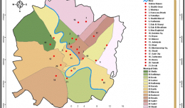
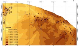
Using gis to create spatial model of some heavy metals in air of Baghdad city
by Ali Neji
0
Full Review »
Published Researches
Geospatial and multi-criteria analysis to rank suitable sites of shallow aquifer recharge with reclaimed water: Application to Nabeul – Hammamet groundwater
by Ali Neji
0
Full Review »
Published Researches
ANALYSIS OF SOME PARAMETERS OF WATER QUALITY IN AL ABASSEIA RIVER STATION
by Ali Neji
0
Full Review »
Published Researches
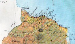
Rainfall and Runoff in the western region of Libya As Climate change Indicators
by Ali Neji
0
Full Review »
Published Researches
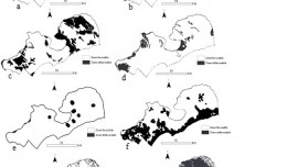
Suitability analysis techniques for monitoring urban growth utilizing multi-criteria GIS and RS: A case study in Oujda and Saidia city, Morocco
by Ali Neji
0
Full Review »
Published Researches
URBAN FURNITURE IN CITIE OF DEVELOPING COUNTRIES
by Ali Neji
0
Full Review »
Published Researches
Using GIS for Highway Design: A Case Study
by Ali Neji
0
Full Review »
Published Researches
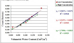
Effect of Chloride Concentration and Bulk Density of Loam Soil texture on Neutron Gauge Calibration Curve
by Ali Neji
0
Full Review »
Published Researches
Spatial assessment of water quality data in a’seeb area, Oman using gis
by Ali Neji
0
Full Review »
Page 5 of 7
1
2
3
4
5
6
7
The Latest
News
Articles and Interviews
Reporting Geo-sp
Published Researches
Precision Technologies Role in the Study of Climate Change Impact
5th International Conference on Water, Energy, Food and Agricultural Technology Istanbul, Turkey, 22-25 January 2019
10th edition of the International Congress & technologies dedicated to geospatial applications
Bluesky’s LiDAR experts educate Mouchel’s water industry professionals
Creation of a digital 3-dimensional model
AeroMetric Announces New High Accuracy Mapping Solution
Interview with George Gartner
Measuring earth’s vital magnetic field
Determine the morphostructure phenomenon, East Khor Al-Zubair by Space Imageries
Detection and monitoring crop of wheat and barley by using NDVI stacking technique and spectral angle mapper algorithm
Tunisian economy in the face of the Covid-19 pandemic: State of play, analysis and outlook
More »
More »
More »
More »
 English
  Français
  العربية