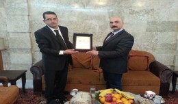
At the beginning of his visit to Iraq, Prof. Mohamed AYARI, president of the Tunisian Association of Digital Geographic Information and president of the Euro-Arab Union of Geomatics met, Mr. Tourhan Almoufti, the Iraqi Minis...
Sheboygan, Wisconsin, May 23, 2013 – AeroMetric announced the addition of a new High Accuracy Mapping Solution for its clients. The new solution is designed to obtain tight vertical accuracy and highly detailed imagery...
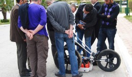
MDS, institution specialized in Georadar technology organized a workshop, within the framework of the 7th edition of Geotunis 8-12 April 2013. The workshop was supervised by Prof. Philippe Xavier, who presented the latest techn...
Google released more than a quarter-century of images of Earth taken from space Thursday compiled into an interactive time-lapse experience. Working with data from the Landsat Program managed by the U.S. Geological Survey, the ...
Dr. Monji Marzouk, Minister of communication and Information Technologies opened on Monday, April 8 2013 the activities of the 7th edition of the international congress geotunis held under the slogan: Through geographic infrast...
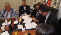
A collaboration protocol was signed on Wednesday morning May 15,2013 inthe Euro-Arab Union of geomatics office inBeirut,Lebanon. The protocol states the technical and scientific cooperation between academics and professionals i...
Dr. Mohamed AYARI, President of the Tunisian Association of Digital Geographic Information and President of the EuroArab Union of Geomatics, visited the Iraqi Republic from December 22 to December 30 2012. During this visit he ...
Although the ultimate goal of the PhoneSat mission was to determine whether a consumer-grade smartphone can be used as the main flight avionics for a satellite in space, the three miniature satellites (named Alexander, Graham a...
Geographic information system (GIS) is a system designed to capture, store, manipulate, analyze, manage, and present all types of geographical data. The acronym GIS is sometimes used for geographical information science or geos...
The Mouchel Urban Drainage Academy (MUDA) trains water industry professionals Aerial mapping company Bluesky is helping water industry professionals understand the potential of laser captured height models. Following a request ...
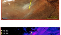
Summary: This past spring and summer, NASA DEVELOPstudent interns used NASA’s Earth Observing System to examine spectral characteristics of dust storms in the Middle East. The results of this study aided project partners by ...
 English
  Français
  العربية