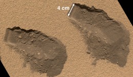
PASADENA, Calif. – NASA’s Mars Curiosity rover has used its full array of instruments to analyze Martian soil for the first time, and found a complex chemistry within the Martian soil. Water and sulfur and chlorine-...
Publication in international scientific magazines and journals, holding an international standard serial number has been subject for debate during the latest period. Scientists, academics and researchers are in a contentious se...
Suliman Emdini Gliwan*1 Kevin Crowe *2 *1Ph.D.Candidate, Faculty of Natural Resource Management, Lakehead University, 955 Oliver Rd, Thunder Bay, ON, Canada (P7B5E1). *2Associate Professor, Faculty of Natural Resource Managemen...
Control of a Hybrid Wind-PV and Energy Storage System Mohammed Al Busaidi, Amer Al-Hinai*, Rashid Al-Abri, Mohammed Al-Badi Electrical & Computer Engineering, Sultan Qaboos University, Oman Abstract—Distributed energy gen...
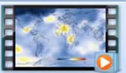
NASA scientists say 2012 was the ninth warmest of any year since 1880, continuing a long-term trend of rising global temperatures. With the exception of 1998, the nine warmest years in the 132-year record all have occurred sinc...
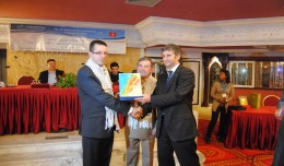
Dr. Mohamed AYARI, president of the Tunisian Association of Digital Geographic Information and president of the Euro-Arab of Geomatics, visited on December 24 and 25 2012 the University of Anbar where he discussed with the pres...
Drone base multiscale Digital Surface Models to planar areas. Dr. Jean A. Doumit Abstract The obtaining of a Digital Surface models (DSMs) at different scales and levels before the appearance of Unmanned Aerial Vehicles (UAV...
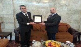
At the beginning of his visit to Iraq, Prof. Mohamed AYARI, president of the Tunisian Association of Digital Geographic Information and president of the Euro-Arab Union of Geomatics met, Mr. Tourhan Almoufti, the Iraqi Minis...
The second Scientific Congress of the Desert Studies Center: Anabar University/ Iraq December 24 to December 26, 2012 The Desert Studies Center in Iraq organizes the second scientific congress from December 24 to December 26,...
The 7th edition of the international congress Geotunis which was opened on April 8 closed its activities on Friday, April 12 2013. The congress gathered the academic, training and investment aspects thanks to the remarkable int...
You can work with maps in the field using Esri’s Collector for ArcGIS app on your iPhone or Android smartphone. You can also use maps to capture spatial and tabular data with the phone’s GPS or by tapping on the map...
 English
  Français
  العربية