Geographic information system (GIS) is a system designed to capture, store, manipulate, analyze, manage, and present all types of geographical data. The acronym GIS is sometimes used for geographical information science or geos...
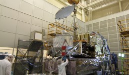
NASA’s Global Precipitation Measurement (GPM) Core Observatory satellite went through its first complete comprehensive performance test (CPT), beginning on Oct. 4, 2012 at NASA’s Goddard ...
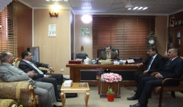
Within the framework of his visit, Dr. Mohamed AYARI, president of the Tunisian Association of Digital Geographic Information and president of the Euro-Arab Union of Geomatics, paid a visit to the University of Takrit where he ...
Time travel to the past or to the future has always been the dream of humanity. We have always imagined life in the past or the future, but what would it be like if we walked around in the city Paris of 2000 years ago though a ...
A new NASA-funded study by the National Center for Atmospheric Research, Boulder, Colo., finds climate model projections that show a greater rise in global temperature are likely to prove more accura...
Bouzayani Rajab [1]/ Abida Zouheir[2] [1] Bouzayani Rajab : Faculty of Economics and Management of Sfax, University of Sfax – Tunisia. E-mail: bouzayanilazher@gmail.com [2] Abida Zouheir : Faculty of Economics and Mana...
The 7th edition of geotunis which closed on April 12, 2013 in hammamet, drew the attention of international companies known in the oil sector, such as Shell, Tunisian Company of Petroleum Activities, Iraqi Oil Institution and o...
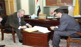
As a respect of his effort aiming at enhancing the scientific exchange at the Arab and international levels, the president of the University of Anbar, Dr kalil Ibrahim, has granted Prof. Mohamed AYARI, president of the Tunisian...
TogliattiKauchuk Plant – Togliatti, Russia Laser scanning as a method of storage of spatial information is used in various economic sectors. In this article, we will focus on laser scanning for industrial design, or more pr...
The President of the Tunisian Association of Digital Geographic Information, Mr. Mohamed AYARI with a delegation from the Association visited Algeria from December 09 to December 15, 2012. The travel included a visit to a numbe...
The second flight of ESA’s newest launch vehicle has been completed from Europe’s Spaceport in Kourou, French Guiana. Two Earth observation satellites, ESA’s Proba-V and Vietnam’s VNREDSat‑1A, were released into diffe...
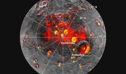
Mercury’s North Polar Region Acquired By The Arecibo Observatory Full Image and Caption A Mosaic of MESSENGER Images of Mercury’s North Polar Region Full Image and Caption Permanently Shadowed Polar Craters Full Ima...
 English
  Français
  العربية