English
  Français
  العربية

ملخص

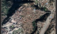
يهدف البحث الى تحليل مسارات السيارات في مدينة بعقوبة ، حيث ان النمو المتزايد في حجم السيارات الداخلة الى العراق عموما والى مدينة بعقوبة خصوصا دون وجود قيود للاستيراد من جهة ، مقابل عدم تزايد الطرق في المدينة مع وجود الظروف الامنية التي فرضت توزيع نقاط تفتيش على مسارات السيارات ، كما فرضت غلق الكثير من الشوارع مما حجم مسار السيارات ، فمن خلال تحليل المسارات الحالية سوف يمكن رسم صورة عن شكل هذه المسارات وعملها ، وقد تم أستخدام في البحث ما قدمته نظم المعلومات الجغرافية من (Functions) في عملية التوزيع والتحليل لاعطاء صورة أشمل لموضوع الدراسة ، فقد استخدمت الباحثة مجموعة من (Functions) تمثلت بـ التحليل الشبكات (Network Analysis) لتحليل مكونات المسارات.
أسئلة يطرحها البحث:
- ماهي مسارات السيارات في مدينة بعقوبة؟
- هل هناك تباين في الوقت المستغرق لقطاع المسارات وصولا الى مخارج المدينة او العكس؟
- هل ان الوقت المستغرق لكل مسار يتناسب مع طول الطريق للمسار؟
- هل تؤثر نقاط التفتيش الموزعة في مدينة بعقوبة على وقت المستغرق للمسار؟
منهجية الدراسة:
اعتمد البحث في منهجيته على:
1) جمع البيانات (الدراسة الميدانية) والتي تمثلت بجمع بيانات المسارات ميدانيا.
2) استخدام ادوات تحليل الشبكات (Network Analysis) واداة (Symbology).
3) التحليل الوصفي لمخرجات نظم المعلومات الجغرافية وبنوعيها الاشكال البيانية والخرائط.
المناقشة و الاستنتاجات:
من خلال استعراض الدراسة يمكن تحديد مسارات السيارات لمدينة بعقوبة ، فضلا عن فاعلية تطبيقات نظم المعلومات الجغرافية في التعامل مع متغيرات الدراسة وابراز الفروقات في التوزيع باساليب متنوعة.
الكاتب
د. وسن شهاب أحمد
Dr. Wasan Shihab Ahmed
Iraq - Diyala – Baqubah city / sheftah
Date of birth & place, Baghdad, 1973
Nationality: Iraqi
Summary:
- PhD in Geography with more than 10 years of work experience in the field of GIS applications, Teaching, NGO, Information Technology, Management.
- Expertise in management and teaching skills.
Academic:
- PhD (Baghdad University) thesis topic (Spatial analysis for infrastructure water – sanitations - electricity – phone land In Karbala city using Geographic Information System Technology).2010
- Master degree in geography 2004 (Diyala university) Specialized (Human Geography-Demographic Geography).
- Graduate in Geography from Diyala University 2000.
- Diploma in Education from Baqubah Institute of Teachers 1993.
Training:
- Remote Sensing in Technology University 2006.
- Basic GIS in Al Qudos School Baghdad 2004.
- Basic of Remote Sensing and GIS (Al- mshkat Institute in al- Mosul) 2002.
- Basic of AoutCAD Technical Institute of Baqubah 1998.
Research work & Papers published:
- Analysis of variation distribution of drinking water sources for the year 2011 in Iraq, using the techniques of geographic information systems (GIS), (Water Resources and Water Security in the Middle East and the Mediterranean Region) conference 14-18 Oct 2012, Antalay –Turky.
- Developing a spatial database based on local municipality records: Buhurz city as case study, (Planning Conference in Iraq – Challenges for Urban Development in Iraqi), (Diyala , Dohuk , Mosel) Universities with Germany (DAAD) Universities 30 sep -2Oct 2012.
- Use of statistical – spatial analysis (spatial statistic) to study the pattern and distribution of educational services for the city of Baqubah, using geographic information systems.(Diyala university conference April 2012.
- The role of geographic information systems in the production contours lines for (Khanaqin).(Thi Qar university conference February 2012), Alustath, issue 206 2013.
- Report of the spatial development requirements in the service of health in Diyala province, 2010 – 2020. (Thi Qar university conference February 2012).
- Design contour maps using a digital elevation model DEM, Journal of Geographical Society, issue 68, 2011.
- Report of Health care services & Environment situation for Al-Moqdadiya city.(result of survey work from 1/10/2010 – 1/11/2010).
- Measuring urban decay in Baqubah city: (AL- Sarray neighborhood as example), was done in conference (Planning Conference in Iraq – Challenges for Urban Development in Iraqi), (Diyala , Dohuk , Mosel) Universities with Germany (DAAD) Universities 3-5/10/2010.
- Physical decay of the buildings and houses in Baqubah, al- Sarai locality: a case study, Presentation was done in conference of (Centre for Motherhood and Childhood – Diyala University) 24-25/2/2010.
- Measuring the security impact on the movement of passengers between the cities of Baqubah and Muqdadiya using a gravity model. Presentation was done in the first central conference of Diyala University,13-14/12/2009.
- Indicators and the reality of water services in the city of Karbala in 2008. AL-Ostath magazine (education college magazine – ebn alroshod /Baghdad university), vol. 102.2009.
- Indicators of fact, residential, social and economic city of Karbala for the year 2008. Presentation was done in the first conference of SRU 29-30/10/2008.
- Agricultural labour force in Diyala province, published in Diyala magazine (Education college magazine) vol.19.2005.
Articles:
- Geographical features and it dimension.
http://www.geoiraq.net/vb/show.php?main=1&id=162
http://www.arabgeographers.net/vb/showthread.php?p=57173#post57173
http://www.4geography.com/vb/t7101.html#post27697
- The contentious relationship between the elements of geographical study. Published in:
http://www.arabgeographers.net/vb/showthread.php?t=10987 http://www.4geography.com/vb/t4080.html
- Approach system to infrastructures in the city. Published in: http://www.arabgeographers.net/vb/showthread.php?t=11097
http://www.4geography.com/vb/t4331.html
- Illiterate university education. Published in: http://www.arabgeographers.net/vb/showthread.php?t=11196 http://www.4geography.com/vb/t4457.html
Professional Experience:
Diyala University (2005-2012)
Worked at different levels in the Organization and performed a variety of jobs.
Assistant Director & Researcher: Working as Assistant Director for Spatial Research Unit (SRU) that is specialized with spatial studies. My duties include supervising the research databases and administrative work, taking lectures on GIS technology for University stuff and government department employees and Preparation and writing reports about SRU activities every three months.
- Participation in the Conference of Education College of Diyala University 24-25/4/2012.
- Participation in the Conference of GIS applications in local governorate, Thi Qar University 24-25/2/2012.
- Participation in the Conference of GIS users for Middle East & Africa, in Beirut Lebanon 1-3/11/2011.
- Translate Network analysis tutorial exercises for ARC GIS 9.3.
- Consultant to the Office of Diyala province for the project (GIS center) .2011.
- Design a poster for the exhibition ESRI Conference held in Beirut for users of GIS in the Middle East and Africa for the period 1-3/11/2011.
- Participation in the Conference (the challenges of regional planning in Iraq), Arbil 2011, and to participate in a workshop (update the design basis for the city of Muqdadiyah), 3-5/10/2011, with the participation of the German DAAD.
- Translate to chapters of guide book ARC GIS 9.3 and make PowerPoint for it
- Managing spatial research unit website.
- Master plan of AL-modadiyah city development (responsible on health care assessment leader team) 2010.
- Training government department employees about GIS technology (more of four coerces) inside and out of Diyala.
- Translate to Network analysis and geodatabase help for ARC GIS 9.1.
- Organized seminars and workshops for different scientific topics.
- Participation in workshops with urban paining department to finalize the master plan for digital map.
- Member of engineering consultative department of Diyala University.
- Responsible for preparation of annual research using GIS technology to support SRU work.
- Coordinate and manage all researchers (permanent & part time) in SRU.
- Working on product atlas for Baqubah city, responsible of major sector in the city (draw various land use).
- Translate to chapters of guide book ARC GIS 9.0 and make PowerPoint for it.
Teacher: Worked as a teacher to teach geographical region of continent of Africa and Australia for two years & teaching English test for Geography. I was assistant professor at the practical side of teaching modern techniques in geography to graduate students for one semester.
- Delivered lectures in English language.
- Supervised the project work of final year students in graduation.
- Member of examinations council for finals year examinations.
Executive Director 2005: Worked as Executive Director on advisory office of Education college Diyala university. Organized different training programs and developed the preparatory process for those programs the allocation of space and determining the exact time and complete the formalities on the subject before and after the training program.
- Prepared Training Courses for government employees with the help of teacher’s from different department.
- Prepared Reports to update seniors about the Course progress and results achieved.
GIS Assistant 2004: Worked in GIS lab to assist postgraduate training program students in geographic information systems and assist them in completing assigned thesis including the use of GIS technology and statistical programs to analyse data of their studies.
- Imparted training to postgraduate student on GIS technology and how they can use it with their project work.
- Imparted training to student on statistical methods and analysis procedures for they data.
- Imparted training to postgraduate student about computers & internet usage.
Danish Refugee Cancel (2003 – 2004)
Database assistant: Worked as a database assistant and performed various database operations. The work included Collection of data information form for uprooted destroyed. and supervision of training of new employees on how to fill out the form and means its contents, and I was responsible for the delivery of field teams forms to and received by them in accordance with the numbering International Organization for Migration to those forms, and also responsible for correcting forms that have incorrect data by interviewing the related .
- Data collection for questionnaire form regarding internal displacement families (IDP).
- Imparted training to new employs on handling questionnaire form so that they can fill it with different categories of information.
- Verifying and updating information to database.
- Visiting internal displacement families (once in month) and recording their Information.
Field Assistant: Worked as Field Assistant for 10 months, I was assistant captain in charge of Khalis in Diyala province. Our work was on three main pivots of registration, monitoring, and support. where we registering the families that were displaced from areas inhabited from the impact of the war, whereas the control process is the process of checking Many families and install the addresses to facilitate humanitarian access to them, has supervised several operations for distribution
- Registered internal displacement families by visiting them in camps.
- Distribution for humanity materials to (IDB).
- Monitored moving (IDB) in camps they live, to give help and support to them.
- Participation in teams meeting and write reports about what team did in their visit for the day to find right status.
- Assisted the manager assistant as translator in her field visits to camps.
Primary School name (1993-1996)
- Worked as a Teacher to take different classes on Mathematics and Reading.
- Took part in various Teachers’ training programs.
Computer skills:
1- GIS and Remote Sensing programs (ArcGIS 10, ArcGIS 9.x ,(Arc view 3.x and it extensions (spatial analysis – D3 analysis – Network analysis), AoutCAD, Math lap 5.x – ArcGIS 9.1& 9.3 –ArcGIS 10 - ERDAS 8.3, Global Mapper 10, GeoDa 9.x).
2- Microsoft Office (Word, Excel, PowerPoint, Access), SPSS.x , Research Project (database program).