Director General of The Royal Jordanian Geographic center Dr. Dean. Engineer Director General Ouni Hdhawna was chosen as a member of the scientific council of the international congress Geotunis 7thedition which will be held fr...
S K AAl-Hummadi[1] N S Nuaimy[2] A L Ubaidy[3] 1Ministry of science and Technology, ,Remote sensing center, Iraq E-mail: shathamaster@yahoo.com 2Ministry of science and Technology, Remote sensing center, Iraq E-mail: ade...
WEAP (Water Evolution and Planning) has been looking for solutions to preserve fresh water and developing strategies to live within certain water budget in a sustainable manner. WEAP’s teamwork is working in almost all over t...
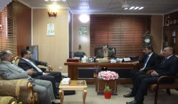
As a respect of his effort aiming at enhancing the scientific exchange at the Arab and international levels, the president of the University of Anbar, Dr kalil Ibrahim, has granted Prof. Mohamed AYARI, president of the Tunisian...
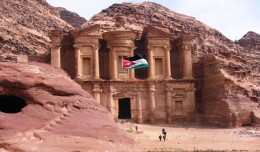
The 7th edition of geotunis which closed on April 12, 2013 in hammamet, drew the attention of international companies known in the oil sector, such as Shell, Tunisian Company of Petroleum Activities, Iraqi Oil Institution and o...
The Second session of the International Symposium Precision Technologies Role in the Study of Climate Change Impact and its implications on the Economic and Natural Structure: The reality and suggested solutions Istanbul, Turke...
Modeling Ripeness Grading of Palm Oil Fresh Fruit Bunches through Image Processing using Artificial Neural Network Osama M. Ben Saaed1, Meftah Salem M Alfatni1,2*, Abdul Rashid Mohamed Shariff3 and Hadya S Hawedi1 1Faculty of I...
DETECTIONS OF BUILDINGSDIGITAL SURFACE MODELS DEFORMATIONS GENERATED FROM DRONES NADIR IMAGES Jean A. Doumit*, Souhail F. Awad*,Evgeny N. Kiselev** *Lebanese University, Faculty of Letters and Human Sciences, Department of g...
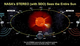
On Nov. 20, 2012, at 7:09 a.m. EST, the sun erupted with a coronal mass ejection or CME. Not to be confused with a solar flare, a CME is a solar phenomenon that can send solar particles into space and can reach Earth one to thr...
Google released more than a quarter-century of images of Earth taken from space Thursday compiled into an interactive time-lapse experience. Working with data from the Landsat Program managed by the U.S. Geological Survey, the ...
Bouzayani Rajab [1]/ Abida Zouheir[2] [1] Bouzayani Rajab : Faculty of Economics and Management of Sfax, University of Sfax – Tunisia. E-mail: bouzayanilazher@gmail.com [2] Abida Zouheir : Faculty of Economics and Mana...
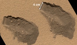
PASADENA, Calif. – NASA’s Mars Curiosity rover has used its full array of instruments to analyze Martian soil for the first time, and found a complex chemistry within the Martian soil. Water and sulfur and chlorine-...
 English
  Français
  العربية