ME_healthFig1

NASA DEVELOP: Middle East Public Health and Air Quality

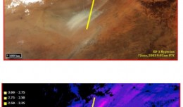
Summary: This past spring and summer, NASA DEVELOPstudent interns used NASA’s Earth Observing System to examine spectral characteristics of dust storms in the Middle East. The results of this study aided project partners by ...
by Lamouchi Helmi
0


708622main_PressConf20121126_full_34x3_226-170

MESSENGER Finds New Evidence for Water Ice at Mercury’s Poles

Mercury’s North Polar Region Acquired By The Arecibo Observatory Full Image and Caption A Mosaic of MESSENGER Images of Mercury’s North Polar Region Full Image and Caption Permanently Shadowed Polar Craters Full Ima...
by Lamouchi Helmi
0


basrahuniv (Large)

University of literature of Basra holds its 5th edition of the Scientific Congress

  Geo SP has been informed that the University of Basra in south of Iraq is preparing the 5th edition of its scientific congress in mid spring 2013. The congress which will be sponsored by the president of the University o...
by Lamouchi Helmi
0


700760main_ST_equidistant_orbit-466

NASA Spacecraft Observe Nov. 20 Solar Eruption

On Nov. 20, 2012, at 7:09 a.m. EST, the sun erupted with a coronal mass ejection or CME. Not to be confused with a solar flare, a CME is a solar phenomenon that can send solar particles into space and can reach Earth one to thr...
by Lamouchi Helmi
0


707628main_pia16294-946

Global Sea Level

    This figure shows changes in global mean sea level as measured by satellite altimetry (NASA/CNES Topex/Poseidon and Jason-1; and NASA/CNES/NOAA/EUMETSAT Jason-2) between 1992 to 2012. The data have been averaged t...
by Lamouchi Helmi
0


sig_

Geographic information system

Geographic information system (GIS) is a system designed to capture, store, manipulate, analyze, manage, and present all types of geographical data. The acronym GIS is sometimes used for geographical information science or geos...
by Geo-SP
0