5th International Conference on Water Resources and Arid Environments 7-9 January 2013 Organizers: Prince Sultan Bin Abdulaziz International Prize for Water (PSIPW) King Saud University, represented by the Prince Sultan Institu...
Dr. Sayyed Hassan Tabatabaei (Assistant Professor) 1- Personal Identification: First name: Sayyed Hassan Last name: Tabatabaei Birthday: 22 May 1973 Birth place: Isfahan, IRAN Marriage statues: Married Children: Two E-mail: sta...
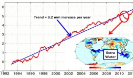
This figure shows changes in global mean sea level as measured by satellite altimetry (NASA/CNES Topex/Poseidon and Jason-1; and NASA/CNES/NOAA/EUMETSAT Jason-2) between 1992 to 2012. The data have been averaged t...
 English
  Français
  العربية