Control of a Hybrid Wind-PV and Energy Storage System Mohammed Al Busaidi, Amer Al-Hinai*, Rashid Al-Abri, Mohammed Al-Badi Electrical & Computer Engineering, Sultan Qaboos University, Oman Abstract—Distributed energy gen...
Modeling Ripeness Grading of Palm Oil Fresh Fruit Bunches through Image Processing using Artificial Neural Network Osama M. Ben Saaed1, Meftah Salem M Alfatni1,2*, Abdul Rashid Mohamed Shariff3 and Hadya S Hawedi1 1Faculty of I...
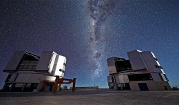
On a remote mountaintop, 2600 metres above sea level in the Chilean Atacama Desert, lies the world’s most advanced visible-light observatory. The European Southern Observatory’s Ver...
Geographic information system (GIS) is a system designed to capture, store, manipulate, analyze, manage, and present all types of geographical data. The acronym GIS is sometimes used for geographical information science or geos...
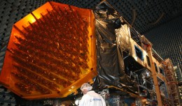
ARTES 8 Alphabus/Alphasat is dedicated to the development and deployment of the Alphasat satellite. Alphasat is being built in partnership between ESA and European operator Inmarsat by Astrium. It is the first satellite to us...
Publication in international scientific magazines and journals, holding an international standard serial number has been subject for debate during the latest period. Scientists, academics and researchers are in a contentious se...
Google released more than a quarter-century of images of Earth taken from space Thursday compiled into an interactive time-lapse experience. Working with data from the Landsat Program managed by the U.S. Geological Survey, the ...
RICHMOND HILL, Ontario, Canada, May 03, 2013 – PCI Geomatics, a world-leading developer of remote sensing and photogrammetric software and systems, announced today that it now supports KOMPSAT-3 imagery within its softwa...
Suliman Emdini Gliwan*1 Kevin Crowe *2 *1Ph.D.Candidate, Faculty of Natural Resource Management, Lakehead University, 955 Oliver Rd, Thunder Bay, ON, Canada (P7B5E1). *2Associate Professor, Faculty of Natural Resource Managemen...
DETECTIONS OF BUILDINGSDIGITAL SURFACE MODELS DEFORMATIONS GENERATED FROM DRONES NADIR IMAGES Jean A. Doumit*, Souhail F. Awad*,Evgeny N. Kiselev** *Lebanese University, Faculty of Letters and Human Sciences, Department of g...
The President of the Tunisian Association of Digital Geographic Information, Mr. Mohamed AYARI with a delegation from the Association visited Algeria from December 09 to December 15, 2012. The travel included a visit to a numbe...
WEAP (Water Evolution and Planning) has been looking for solutions to preserve fresh water and developing strategies to live within certain water budget in a sustainable manner. WEAP’s teamwork is working in almost all over t...
 English
  Français
  العربية