Publication in international scientific magazines and journals, holding an international standard serial number has been subject for debate during the latest period. Scientists, academics and researchers are in a contentious se...
On Monday, April 8, 2013, the Minister of Information Technologies and Communication, Dr Monji Marzouk, in company with governmental stuff and the president of Geotunis, opened the international exhibition of geomatics technolo...
PERTH, Australia, May 6, 2013 — (PRNewswire) — Mike Cunneen today announces EggMaps HD 1.05, an update to his popular #1-ranked navigation app for iPad that provides Google Maps at full-screen high resolution. Version 1....
Time travel to the past or to the future has always been the dream of humanity. We have always imagined life in the past or the future, but what would it be like if we walked around in the city Paris of 2000 years ago though a ...
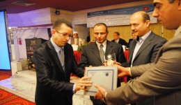
Director General of The Royal Jordanian Geographic center Dr. Dean. Engineer Director General Ouni Hdhawna was chosen as a member of the scientific council of the international congress Geotunis 7thedition which will be held fr...
Regarding the importance of geographic information in the improving the security performance, the Tunisian security institution participated in the 7th edition of Geotunis, which was held in Hammamet 8- 12 April 2013. A study d...
Sheboygan, Wisconsin, May 23, 2013 – AeroMetric announced the addition of a new High Accuracy Mapping Solution for its clients. The new solution is designed to obtain tight vertical accuracy and highly detailed imagery...
You can work with maps in the field using Esri’s Collector for ArcGIS app on your iPhone or Android smartphone. You can also use maps to capture spatial and tabular data with the phone’s GPS or by tapping on the map...
The international Trimble company, specialized in the production of positioning via satellite devises, surveying techniques and mapping, participated in the 7th edition of geotunis, where it presented its latest techniques in...
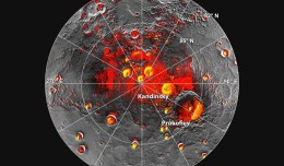
Mercury’s North Polar Region Acquired By The Arecibo Observatory Full Image and Caption A Mosaic of MESSENGER Images of Mercury’s North Polar Region Full Image and Caption Permanently Shadowed Polar Craters Full Ima...
New report charts current and future damage from the region’s rapidly changing climate and calls for strong leadership in preparing countries and communities to face the threat WASHINGTON, December 5, 2012 – The ...
Study the characteristics and nature of the Indian dates tree. Tamarindus Indica L In the southwestern region (Jizan and Asir) Corresponding Author Mosaed Saeed Ali Alhader King Abdulaziz City for Science and Technology General...
 English
  Français
  العربية