Abstract
The study aims to analyze data that relate to the contrast of growth levels in the West Bank’s districts. Such a contrast will help in bridging the gap between levels of growth in these districts. Data were collected from the Palestinian Bureau of Statistics and various government authorities. Factor analysis technique and GIS were used in order to extract similarities and differences in levels of growth in West Bank districts.
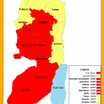
The study has revealed that West Bank districts can be divided into factors according to their levels of growth. First Factor enjoyed an eigenvalue of 68% which explains variances of levels of growth. Dominant West Bank districts of high growth have loaded highly in first factor such as Nablus, Salfeet, Ramallah and Al-Bireh, Bethlehem, Hebron, Jenin, and Jerusalem. These districts are the oldest in terms of their establishments. Second Factor enjoyed an eigenvalue of 20% and explained variances of levels of growth. Newly established Palestinian districts in the West Bank of low levels of growth have loaded on this factor such as Tubas, Tulkarm, Qalqeliyah, and Jericho. The study recommends of using more levels of growth variables and districts of Gaza Strip in future studies for the purpose of revealing more similarities and differences between Palestinian districts.
 English
  Français
  العربية


