glacier-ERS1-2_1992-2011_L,0

Clearest evidence yet of polar ice losses

30 November 2012 After two decades of satellite observations, an international team of experts brought together by ESA and NASA has produced the most accurate assessment of ice losses from Antarctica and Greenland to date. This...
by Lamouchi Helmi
0


images

Urgent Action Needed on Climate Change in Arab World

New report charts current and future damage from the region’s rapidly changing climate and calls for strong leadership in preparing countries and communities to face the threat      WASHINGTON, December 5, 2012 – The ...
by Lamouchi Helmi
0


700760main_ST_equidistant_orbit-466

NASA Spacecraft Observe Nov. 20 Solar Eruption

On Nov. 20, 2012, at 7:09 a.m. EST, the sun erupted with a coronal mass ejection or CME. Not to be confused with a solar flare, a CME is a solar phenomenon that can send solar particles into space and can reach Earth one to thr...
by Lamouchi Helmi
0


image4a

Forest products industry slowly recovers from recession

18 December 2012, Rome - The global forest products industry is slowly recovering from the economic crisis, with the Asia-Pacific region and particularly China taking the lead. New data published by FAO indicate that on avera...
by Lamouchi Helmi
0


708622main_PressConf20121126_full_34x3_226-170

MESSENGER Finds New Evidence for Water Ice at Mercury’s Poles

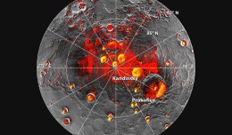
Mercury’s North Polar Region Acquired By The Arecibo Observatory Full Image and Caption A Mosaic of MESSENGER Images of Mercury’s North Polar Region Full Image and Caption Permanently Shadowed Polar Craters Full Ima...
by Lamouchi Helmi
0


Alphasat_1-XL_large

Alphabus/Alphasat

ARTES 8 Alphabus/Alphasat is dedicated to the development and deployment of the Alphasat satellite. Alphasat is being built in partnership between ESA and European operator Inmarsat by Astrium. It is the first satellite to us...
by Lamouchi Helmi
0


sig_

Geographic information system

Geographic information system (GIS) is a system designed to capture, store, manipulate, analyze, manage, and present all types of geographical data. The acronym GIS is sometimes used for geographical information science or geos...
by Geo-SP
0


images

PCI Geomatics Software Supports KOMPSAT-3 Sensor

RICHMOND HILL, Ontario, Canada, May 03, 2013 – PCI Geomatics, a world-leading developer of remote sensing and photogrammetric software and systems, announced today that it now supports KOMPSAT-3 imagery within its softwa...
by Lamouchi Helmi
0


707628main_pia16294-946

Global Sea Level

    This figure shows changes in global mean sea level as measured by satellite altimetry (NASA/CNES Topex/Poseidon and Jason-1; and NASA/CNES/NOAA/EUMETSAT Jason-2) between 1992 to 2012. The data have been averaged t...
by Lamouchi Helmi
0