Home
About us
Contact
English
Français
العربية
Home
About us
Evaluation Committee
Publishing Guide
Research
Events
Books and letters
Books
Contact
Sort
Recent
Most Commented
Random
Published Researches
GIS Land use monitoring and its impact on the growth of East Beirut
by Ali Neji
0
Full Review »
Published Researches
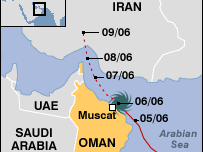
Assessing the Areas Affected by Cyclone Gonu in the Sultanate of Oman Using Remote Sensing
by Ali Neji
0
Full Review »
Published Researches
CHANGE DETECTION IN HOUR-IBN NAJAM / MIDDLE OF IRAQ BY USING WATER INDEX (W.I) ALGBRA
by Ali Neji
0
Full Review »
Published Researches
Atmospheric PM10 pollution in the mining basin of Gafsa (south-western of Tunisia): statistical analysis and cartography
by Ali Neji
0
Full Review »
Published Researches
URBAN FURNITURE IN CITIE OF DEVELOPING COUNTRIES
by Ali Neji
0
Full Review »
Published Researches
Modeling Ripeness Grading of Palm Oil Fresh Fruit Bunches through Image Processing using Artificial Neural Network
Modeling Ripeness Grading of Palm Oil Fresh Fruit Bunches through Image Processing using Artificial Neural Network Osama M. Ben Saaed1, Meftah Salem M Alfatni1,2*, Abdul Rashid Mohamed Shariff3 and Hadya S Hawedi1 1Faculty of I...
by Lamouchi Helmi
0
Full Story »
Published Researches
ANALYSIS OF SOME PARAMETERS OF WATER QUALITY IN AL ABASSEIA RIVER STATION
by Ali Neji
0
Full Review »
Published Researches
Implementing a sensor network for monitoring drought indicators
by Ali Neji
0
Full Review »
Published Researches
Using gis to create spatial model of some heavy metals in air of Baghdad city
by Ali Neji
0
Full Review »
Page 4 of 8
‹ Previous
1
2
3
4
5
6
7
Next ›
Last »
The Latest
News
Articles and Interviews
Reporting Geo-sp
Published Researches
International Conference on Social and Human Sciences
Precision Technologies Role in the Study of Climate Change Impact
5th International Conference on Water, Energy, Food and Agricultural Technology Istanbul, Turkey, 22-25 January 2019
Bluesky’s LiDAR experts educate Mouchel’s water industry professionals
Creation of a digital 3-dimensional model
AeroMetric Announces New High Accuracy Mapping Solution
Interview with George Gartner
Measuring earth’s vital magnetic field
Selecting Suitable Sites for Wind Energy harvesting in Iraq using GIS Techniques
Machine Learning and Statically for Evaluating the Classification of Medical and Lab Services
Study the characteristics and nature of the Indian dates tree. Tamarindus Indica L In the southwestern region (Jizan and Asir)
More »
More »
More »
More »
 English
  Français
  العربية