Home
About us
Contact
English
Français
العربية
Home
About us
Evaluation Committee
Publishing Guide
Research
Events
Books and letters
Books
Contact
Sort
Recent
Most Commented
Random
Published Researches
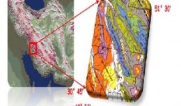
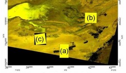
Preparing digital lineament map of bangestan structure, using satellite data and remote sensing techniques
by Ali Neji
0
Full Review »
Published Researches
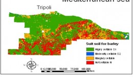
Evaluation of land suitability using fuzzy logic in the north west of Libya
by Ali Neji
0
Full Review »
Published Researches
Comparison between «Local» and «Regional» spectrometric soil total carbon models calibrated in Djerid arid area.
by Ali Neji
0
Full Review »
Published Researches
Challenges and Opportunities of Using Integrated Data Viewer for Disaster Mitigation in Non Space Faring Countries of the Less Developed World: IAA – IGMASS Projects in Africa.
by Ali Neji
0
Full Review »
Published Researches
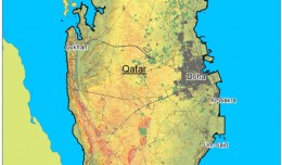
Water Scarcity in Qatar and Prospects for Resolutions
by Ali Neji
0
Full Review »
Published Researches
Detection and monitoring crop of wheat and barley by using NDVI stacking technique and spectral angle mapper algorithm
S K AAl-Hummadi[1] N S Nuaimy[2] A L Ubaidy[3] 1Ministry of science and Technology, ,Remote sensing center, Iraq E-mail: shathamaster@yahoo.com 2Ministry of science and Technology, Remote sensing center, Iraq E-mail: ade...
by Lamouchi Helmi
0
Full Story »
Published Researches
Relationship between Soil Physico-chemical Properties and the Spectral Reflectance’s of Some Soil Sites from Arbil Governorate
by Ali Neji
0
Full Review »
Published Researches
Scale effects in the assessment of digital terrain models and slope maps
by Ali Neji
0
Full Review »
Published Researches
Using gis to create spatial model of some heavy metals in air of Baghdad city
by Ali Neji
0
Full Review »
Page 4 of 8
‹ Previous
1
2
3
4
5
6
7
Next ›
Last »
The Latest
News
Articles and Interviews
Reporting Geo-sp
Published Researches
International Conference on Social and Human Sciences
Precision Technologies Role in the Study of Climate Change Impact
5th International Conference on Water, Energy, Food and Agricultural Technology Istanbul, Turkey, 22-25 January 2019
Bluesky’s LiDAR experts educate Mouchel’s water industry professionals
Creation of a digital 3-dimensional model
AeroMetric Announces New High Accuracy Mapping Solution
Interview with George Gartner
Measuring earth’s vital magnetic field
Selecting Suitable Sites for Wind Energy harvesting in Iraq using GIS Techniques
Machine Learning and Statically for Evaluating the Classification of Medical and Lab Services
Study the characteristics and nature of the Indian dates tree. Tamarindus Indica L In the southwestern region (Jizan and Asir)
More »
More »
More »
More »
 English
  Français
  العربية