Home
About us
Contact
English
Français
العربية
Home
About us
Evaluation Committee
Publishing Guide
Research
Events
Books and letters
Books
Contact
Sort
Recent
Most Commented
Random
Published Researches
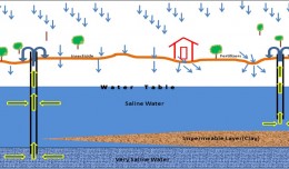
Evaluation of Groundwater for Irrigation at Safwan area. South Iraq.
by Ali Neji
0
Full Review »
Published Researches
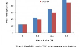
Effects of water-retaining agent (Sky Gel) ongrowth, yield and water use efficiency of Wheat (Triticumaestivum L.)
by Ali Neji
0
Full Review »
Published Researches
USING GIS FOR SOLVING ENVIRONMENTAL PROBLEM
by Ali Neji
0
Full Review »
Published Researches
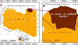
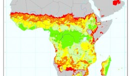
Using Remote Sensing Technique (NDVI) for Monitoring Vegetation Degradation in Al Jabal Al Akhdar – Libya
by Ali Neji
0
Full Review »
Published Researches
Rainfall and Runoff in the western region of Libya As Climate change Indicators
by Ali Neji
0
Full Review »
Published Researches
The effect of water limitation on water relations, growth and seed yield of four soybean (Glycine max merri.) genotypes
by Ali Neji
0
Full Review »
Published Researches
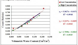
Effect of Chloride Concentration and Bulk Density of Loam Soil texture on Neutron Gauge Calibration Curve
by Ali Neji
0
Full Review »
Published Researches
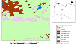
Soil Productivity Rating Index Model Using Geographic Information System in Libya
by Ali Neji
0
Full Review »
Published Researches
Environmental impacts of brick factories in Iraq
by Ali Neji
0
Full Review »
Page 4 of 8
‹ Previous
1
2
3
4
5
6
7
Next ›
Last »
The Latest
News
Articles and Interviews
Reporting Geo-sp
Published Researches
International Conference on Social and Human Sciences
Precision Technologies Role in the Study of Climate Change Impact
5th International Conference on Water, Energy, Food and Agricultural Technology Istanbul, Turkey, 22-25 January 2019
Bluesky’s LiDAR experts educate Mouchel’s water industry professionals
Creation of a digital 3-dimensional model
AeroMetric Announces New High Accuracy Mapping Solution
Interview with George Gartner
Measuring earth’s vital magnetic field
Selecting Suitable Sites for Wind Energy harvesting in Iraq using GIS Techniques
Machine Learning and Statically for Evaluating the Classification of Medical and Lab Services
Study the characteristics and nature of the Indian dates tree. Tamarindus Indica L In the southwestern region (Jizan and Asir)
More »
More »
More »
More »
 English
  Français
  العربية