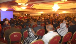
Arab and African participation in the 7th edition of Geotunis held between April 8-12 2013 in the Royal Resort hotel, Hammamet in the presence of experts, specialists, scientists, representatives of ministries, companies and pe...
Information Technology Infrastructure Library ITIL Oldo-lina Foundation for the French East development in collaboration with the Euro-Arab union Geomatics organizes training for IT Service Management ITIL V3 Will be held in Ly...
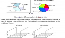
Machine Learning and Statically for Evaluating the Classification of Medical and Lab Services Muna R. Harbi1,,Loay E. George2 1.Department of Physics, General Directorate of Thi-Qar Education, Ministry of Education, Thi-Qar, Ir...
The Faculty of Earth Sciences Geography and Spatial Configuration, University of Wahran, organized the 4th edition of Algerian Geographic Days on 11/12 December 2012. A number of academics, researchers, and amateurs in the fi...
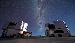
On a remote mountaintop, 2600 metres above sea level in the Chilean Atacama Desert, lies the world’s most advanced visible-light observatory. The European Southern Observatory’s Ver...
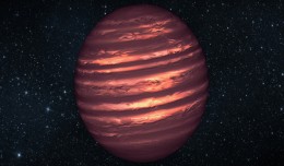
PASADENA, Calif. — Astronomers using NASA’s Spitzer and Hubble space telescopes have probed the stormy atmosphere of a brown dwarf, creating the most detailed “weather map” yet for this class of cool, st...
RICHMOND HILL, Ontario, Canada, May 03, 2013 – PCI Geomatics, a world-leading developer of remote sensing and photogrammetric software and systems, announced today that it now supports KOMPSAT-3 imagery within its softwa...
Although the ultimate goal of the PhoneSat mission was to determine whether a consumer-grade smartphone can be used as the main flight avionics for a satellite in space, the three miniature satellites (named Alexander, Graham a...
The second flight of ESA’s newest launch vehicle has been completed from Europe’s Spaceport in Kourou, French Guiana. Two Earth observation satellites, ESA’s Proba-V and Vietnam’s VNREDSat‑1A, were released into diffe...
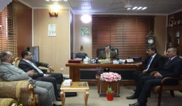
As a respect of his effort aiming at enhancing the scientific exchange at the Arab and international levels, the president of the University of Anbar, Dr kalil Ibrahim, has granted Prof. Mohamed AYARI, president of the Tunisian...
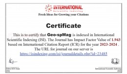
Geo-spMag Journal Achieves Impact Factor of 1.943 in ISI Indexing Geo-spMag Journal Achieves Impact Factor of 1.943 in ISI Indexing In a significant milestone for Arab scientific publishing, the international peer-reviewed jour...
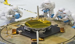
The sole secondary mirror and another primary mirror that will fly aboard NASA’s James Webb Space Telescope arrived at NASA’s Goddard Space Flight Center in Greenbelt, Md., on Nov....
 English
  Français
  العربية