• Home
  • About us
  • Contact
  • en  English
  • fr  Français
  • ar  العربية

Geography & Sciences Publications

 
  • Home
  • About us
  • Evaluation Committee
  • Publishing Guide
  • Research
  • Events
  • Books and letters
    • Books
  • Contact
Random Article
 

Titles of published researches

  • Use of Space Technologies and GIS to Study Groundwater Potential Zones in the Western Coast of the Kingdom of Saudi Arabia*Dr. Machaael Bent Mohamed Al Saud
  • Using QuickBird Satellite Images to Study Salinity Effect on Date Palm Field*Mohamed Alhammadi.
  • SPATIAL ASSESSMENT OF WATER QUALITY DATA IN A’SEEB AREA, OMAN USING GIS*Ghazi A. Al-Rawas1 & Caterina Valeo2.
  • Multiscale analysis of 3D GPR data using the continuous wavelet transform*Sid-Ali Ouadfeul.
  • Mapping of water nitrogen pollution from agricultural sources in Poland*Wozniak Edyta, Nasilowska Sylwia.
  • A Paper on Building a Geo-KSWN Ontologies*Samir M. Adam.
  • Morphometric, hydrogeologic and hydrochemical analyses of solar saltwork pond region, in Meha area, northwest Sharqat city, Iraq*S.A. Salih1, J.H. Ulaiwi2, A.M.S. Al-Tarif2 and A.I. Al-Juboury3
  • Using of GIS spatial analyses to study the geometry of selected location for dam reservoir on Wadi Al-Jirnaf, west of Shirqat Area, Iraq*S.A. Salih  and A.M.S. Al-Tarif.
  • Incorporation of access constraints into the economic optimisation of cut-off grade*R. Behloul , A. Yahiaoui.
  • Satellite Tech-Identification of Groundwater Offshore Springs in Red Sea along Jeddah-Rabigh Costal Belt: A Case of Fault-Zone-Aquifers in Crystalline Rocks of Arabian Shield*Nayyer Alam Zaigham*Omar Siraj Aburizaiza*Zeeshan Alam Nayyer*Gohar Ali Mehar*Azhar Siddiq and Sabahat Noor.
  • SATELLITE GRAVITY REVEALS DEEP-SEATED BASEMENT STRUCTURES: Case Studies of Pakistan and Tunisia*Nayyer Alam Zaigham* and Zeeshan Alam Nayyar **.
  • Evaluation of land suitability using fuzzy logic in the north west of Libya*Nagib Froja¹, Adebayo J. Adeloye ² and Roland Burkhard³
  • Structural and geomorphological analysis of mature delta of Bangladesh through remote sensing and geographic information system*Md. Sabber Ahamed.
  • COASTLINE CHANGE MONITORING BASED ON COMPUTER VISION AND REMOTE SENSING IN ISLAND OF DJERBA, TUNISIA*Maged Bouchahma and Wanglin Yan.
  • Modelling land-use change and future scenario in Madrid, Spain, using Idrisi Taiga Land Change Modeler.*Gallardo Beltrán, Marta & Martínez Vega, Francisco Javier.
  • Preparing Digital Lineament Map of Bangestan Structure, Using Satellite Data and Remote Sensing Techniques*Foroogh Beik.
  • “INTEGRATION OF SYSTEM DYNAMIC AND SPATIAL DYNAMIC MODELS TO SUPPORT REGIONAL DEVELOPMENT PLANNING” (Case Study in Java Madura Bali)*Ferrari Pinem*, Sigit Purnomo*, Aris Poniman*,  Suharto Widjojo*, Mulyanto Darmawan*.
  • Integration Study of Vegetation cover in Babel governorate By using Remote Sensing data and GIS*Dr.Prof. Amer Atyah Laftah.
  • Determine The Regression of Agricultural areas by using Landsat images for mid Euphrates – Iraq*Dr. Omar Burhan AL-Jarrah.
  • EVALUATION OF GROUND WATER POTENTIAL ZONES OF NAKKAVAGU CATCHMENT IN HYDERABAD, ANDHRA PRADESH, INDIA BY USING REMOTE SENSING AND GIS TECHNIQUE*Dr. Ishrath.
  • Main vegetation types and the important values of the Jebel Bura’ protected area, Yemen By:*Dr. Abdul Wali Ahmed Al-Khulaidi.
  • USING GIS TO CREATE SPATIAL MODEL OF SOME HEAVY METALS IN AIR OF BAGHDAD CITY*Bassim Mohammed Hashim**, Mahdi Saleh Al- Rubaie, Dr. Maitham Abdullah Sultan.
  • Predicting moisture content of organic-rich soils using ASD reflectance at simulated hyperspectral reflectance of HyMap sensor*Amer Alroichdi and Jarah Alzubi.
  • WATER QUALITY ASSESSMENT OF EUPHRATES RIVER WITHIN THE MIDDLE OF IRAQ*Asst. Prof. Dr. Alaa H. Al-Fatlawi.
  • GIS and Remote Sensing Techniques Applications for Sustainable Transport Mobility (A Case Study of Developing Noise Measurement and its Abatement in Libya)*Abdel Majeda, Dr S.P.Bindra, & Dr Hadi Shandool.
  • Studying Environmental Hazards of Al Jabal Al Akhdar Soils, Libya Using Remote Sensing and Geographical Information System (GIS)*A.S. El Hassanien« , E.I. Gaber«, A. H. El Nahry«¬ and A.S. Ahmed«.
  • ASSESSING THE AREAS AFFECTED BY CYCLONE GONU IN THE SULTANATE OF OMAN USING REMOTE SENSING*Andy Y. Kwarteng§ and Ghazi A. Al-Rawas*
  • Identification of groundwater artificial recharge sites using Fuzzy logic: A case study of Shahrekord plain, Iran*A. Mahdavi1, S.H. Tabatabaei 2, M. Nouri3 and R. Mahdavi4
  • On Some Aspects of Climate Change, Drought and Mitigation of Risk of Desertification in Arid Regions of Georgia*T. Davitashvili1, A.Khantadze, 2 K. Tavartkiladze3
  • Aspects Of ICT Exclusions In Rural Communities Of Iran*Hamid shayan and Alireza bidkhori.
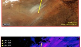
  • ANALYSIS OF ASTER IMAGERY FOR HYDROTHERMAL ALTERATION ZONES EXPLORATION–A CASE STUDY NUQRAH AREA, SAUDI ARABIA*Assiri, Aa, *, Mousa, Hb.
  • Urban Land Use Analysis with a Sustainable-Development Approach Using GIS and RS: Case Study Saadiyeh town in Shiraz*Dr.Nafiseh Marsousi-professor assistant, Ali Peyravi.
  • Application of GIS and Factor Analysis in Investigation of Hydrogeochemical Characteristics of Ground Water in Kandukuru Vagu Basin , Nalgonda District ,A.P. India*Ayad Ali Faris  * , Y.Sudhakar Reddy
  • SUSTAINABLITY AND LANDFILL SITE ALLOCATION BY USING GIS: A CASE STUDY FROM RAMALLAH, PALESTINE*MAHAMID, I¹. & THAWABA, S².
  • On Some Aspects of Climate Change, Drought and Mitigation of Risk of Desertification in Arid Regions of Georgia*T. Davitashvili1, A.Khantadze, 2 K. Tavartkiladze3.
  • Analysis of Rainfall-Runoff, Evapotranspiration and Infiltration of Kandukuru Vagu Watershed Nalgonda District A.P. India Using Remote Sensing and GIS Technique*Ayad Ali Faris , Y.Sudhakar Reddy.


Newsletter


Recent
Most Commented
Random


News
img_1322557545_891

Director General of the Royal Jordanian Geographic center A member of the Scientific Council of the international congress Geotunis

Director General of The Royal Jordanian Geographic center Dr. Dean. Engineer Director General Ouni Hdhawna was chosen as a member of the scientific council of the international congress Geotunis 7thedition which will be held fr...
by Lamouchi Helmi
0
Full Story »


News
f0ecbd2a-2ed9-458d-91ab-07e1caedea10-9867cc4df536.small

5th International Conference on Water, Energy, Food and Agricultural Technology Istanbul, Turkey, 22-25 January 2019

5th International Conference on Water, Energy, Food and Agricultural Technology Istanbul, Turkey, 22-25 January 2019   Scientific themes 1-      water resources and desertification and agricultural techniques 2-   ...
by Lamouchi Helmi
0
Full Story »


Articles and Interviews
710733main_Edgett-2-pia16469-673

NASA Mars Rover Fully Analyzes First Soil Samples

PASADENA, Calif. – NASA’s Mars Curiosity rover has used its full array of instruments to analyze Martian soil for the first time, and found a complex chemistry within the Martian soil. Water and sulfur and chlorine-...
by Lamouchi Helmi
0
Full Story »


Published Researches
2

Tunisian economy in the face of the Covid-19 pandemic: State of play, analysis and outlook

Bouzayani Rajab [1]/ Abida Zouheir[2] [1] Bouzayani Rajab : Faculty of Economics and Management of Sfax, University of Sfax – Tunisia. E-mail: bouzayanilazher@gmail.com [2] Abida Zouheir : Faculty of Economics and Mana...
by Lamouchi Helmi
0
Full Story »


Published Researches
bbbbbb

TOOLS FOR A NEW URBAN AGENDA

  Tullia Valeria Di Giacomo (*); F. Paolo Di Giacomo (**) (*)Alpha Consult, Rome; (**) SOGEIT, Tunis   Keywords: GIS, WEBGIS, Urban Agenda, sustainable development Summary: Urban Authorities, civil society, businesses and kno...
by Lamouchi Helmi
0
Full Story »


News
DSC_0125And2more_fused

The President of the Tunisian Association of Digital Geographic Information visits Algeria

The President of the Tunisian Association of Digital Geographic Information, Mr. Mohamed AYARI with a delegation from the Association visited Algeria from December 09 to December 15, 2012. The travel included a visit to a numbe...
by Lamouchi Helmi
0
Full Story »


News
DSC08171

Prof. Mohamed Ayari vists the University of Anbar

Dr. Mohamed AYARI, president of the Tunisian Association of Digital Geographic Information and president of the Euro-Arab of Geomatics, visited on December 24 and 25 2012 the University of Anbar where he discussed with the pres...
by Lamouchi Helmi
0
Full Story »


News
DSC_0391

7th edition of Geotunis closes its activities and announces its recommendations

The 7th edition of the international congress Geotunis which was opened on April 8 closed its activities on Friday, April 12 2013. The congress gathered the academic, training and investment aspects thanks to the remarkable int...
by Lamouchi Helmi
0
Full Story »


Articles and Interviews
1367507172iPad5

Google Maps for iPad Has Mileage with Latest EggMaps Update

PERTH, Australia, May 6, 2013 — (PRNewswire) —  Mike Cunneen today announces EggMaps HD 1.05, an update to his popular #1-ranked navigation app for iPad that provides Google Maps at full-screen high resolution. Version 1....
by Lamouchi Helmi
0
Full Story »


articles
p3-gulfstream

AeroMetric Announces New High Accuracy Mapping Solution

Sheboygan, Wisconsin, May 23, 2013 – AeroMetric announced the addition of a new High Accuracy Mapping Solution for its clients. The new solution is designed to obtain tight vertical accuracy and highly detailed imagery...
by Lamouchi Helmi
0
Full Story »


Published Researches
a4

Selecting Suitable Sites for Wind Energy harvesting in Iraq using GIS Techniques

Selecting Suitable Sites for Wind Energy harvesting in Iraq using GIS Techniques  WEDYAN G. NASSIF1,2, DALILA ELHMAIDI1 , YASEEN  K. Al-TIMIMI2  1 Thermal Radiation Research Unit ,Faculty of Sciences of Tunis ,University  o...
by Lamouchi Helmi
0
Full Story »


News
climate_change_0218

RIEGL launches VZ-6000 Terrestrial Laser Scanner

          RIEGL goes for ultra-long ranges: VZ-6000 offers more than 6,000 m measurement range Horn, Austria, September 24, 2012 – Especially designed for ultra-long range applications in topograp...
by Lamouchi Helmi
0
Full Story »


Page 1 of 71234567


The Latest
 
News
Articles and Interviews
Reporting Geo-sp
Published Researches

1320_effects-image
Precision Technologies Role in the Study of Climate Change Impact
5th International Conference on Water, Energy, Food and Agricultural Technology Istanbul, Turkey, 22-25 January 2019
10th edition of the International Congress & technologies dedicated to geospatial applications
1595_481137111962333_1750011374_n
Bluesky’s LiDAR experts educate Mouchel’s water industry professionals
Creation of a digital 3-dimensional model
AeroMetric Announces New High Accuracy Mapping Solution
Untitled-1
Interview with George Gartner
Measuring earth’s vital magnetic field
a4
Selecting Suitable Sites for Wind Energy harvesting in Iraq using GIS Techniques
Machine Learning and Statically for Evaluating the Classification of Medical and Lab Services
Study the characteristics and nature of the Indian dates tree. Tamarindus Indica L In the southwestern region (Jizan and Asir)

More »
More »
More »
More »

 
Avatars by Sterling Adventures
 

Categories

 
  • articles (5)
  • Articles and Interviews (18)
  • Definitions (1)
  • News (34)
  • publication (1)
  • Published Researches (72)
  • Reporting Geo-sp (2)

Newsletter


Archives

 
  • August 2024 (4)
  • June 2021 (3)
  • May 2019 (5)
  • January 2019 (5)
  • January 2016 (1)
  • September 2013 (1)
  • June 2013 (1)
  • May 2013 (12)
  • April 2013 (10)
  • February 2013 (1)
  • January 2013 (12)
  • December 2012 (7)
  • November 2012 (13)
  • December 2011 (1)


Copyright © 2025 Geography & Sciences Publications All Rights Reserved.