On a remote mountaintop, 2600 metres above sea level in the Chilean Atacama Desert, lies the world’s most advanced visible-light observatory. The European Southern Observatory’s Ver...
Information Technology Infrastructure Library ITIL Oldo-lina Foundation for the French East development in collaboration with the Euro-Arab union Geomatics organizes training for IT Service Management ITIL V3 Will be held in Ly...
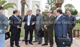
On Monday, April 8, 2013, the Minister of Information Technologies and Communication, Dr Monji Marzouk, in company with governmental stuff and the president of Geotunis, opened the international exhibition of geomatics technolo...
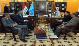
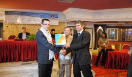
Dr. Mohamed AYARI, president of the Tunisian Association of Digital Geographic Information and president of the Euro-Arab of Geomatics, visited on December 24 and 25 2012 the University of Anbar where he discussed with the pres...
The President of the Tunisian Association of Digital Geographic Information, Mr. Mohamed AYARI with a delegation from the Association visited Algeria from December 09 to December 15, 2012. The travel included a visit to a numbe...
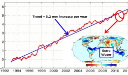
This figure shows changes in global mean sea level as measured by satellite altimetry (NASA/CNES Topex/Poseidon and Jason-1; and NASA/CNES/NOAA/EUMETSAT Jason-2) between 1992 to 2012. The data have been averaged t...
Regarding the importance of geographic information in the improving the security performance, the Tunisian security institution participated in the 7th edition of Geotunis, which was held in Hammamet 8- 12 April 2013. A study d...
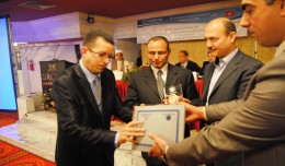
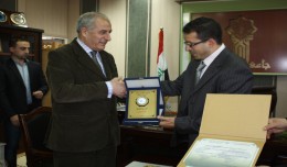
Regarding his efforts in promoting the scientific cooperation between institutions at the Arab and International levels and the use of Geomatics technology, the president of the University of Takrit, Dr. Mzahem Kacem Alkaiat, g...
The 7th edition of the international congress Geotunis which was opened on April 8 closed its activities on Friday, April 12 2013. The congress gathered the academic, training and investment aspects thanks to the remarkable int...
You can work with maps in the field using Esri’s Collector for ArcGIS app on your iPhone or Android smartphone. You can also use maps to capture spatial and tabular data with the phone’s GPS or by tapping on the map...
Publication in international scientific magazines and journals, holding an international standard serial number has been subject for debate during the latest period. Scientists, academics and researchers are in a contentious se...
 English
  Français
  العربية