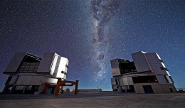
On a remote mountaintop, 2600 metres above sea level in the Chilean Atacama Desert, lies the world’s most advanced visible-light observatory. The European Southern Observatory’s Ver...
The 7th edition of geotunis which closed on April 12, 2013 in hammamet, drew the attention of international companies known in the oil sector, such as Shell, Tunisian Company of Petroleum Activities, Iraqi Oil Institution and o...
RIEGL goes for ultra-long ranges: VZ-6000 offers more than 6,000 m measurement range Horn, Austria, September 24, 2012 – Especially designed for ultra-long range applications in topograp...
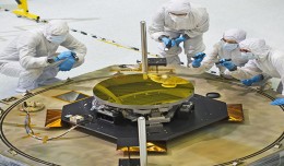
The sole secondary mirror and another primary mirror that will fly aboard NASA’s James Webb Space Telescope arrived at NASA’s Goddard Space Flight Center in Greenbelt, Md., on Nov....
18 December 2012, Rome - The global forest products industry is slowly recovering from the economic crisis, with the Asia-Pacific region and particularly China taking the lead. New data published by FAO indicate that on avera...
S K AAl-Hummadi[1] N S Nuaimy[2] A L Ubaidy[3] 1Ministry of science and Technology, ,Remote sensing center, Iraq E-mail: shathamaster@yahoo.com 2Ministry of science and Technology, Remote sensing center, Iraq E-mail: ade...
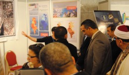
The Tunisian Association of Digital Geographic Information participates in the second scientific congress of desert studies in the Anbar University 24- 26 April 2013, the congress will be held under the slogan “scientific res...
Bouzayani Rajab [1]/ Abida Zouheir[2] [1] Bouzayani Rajab : Faculty of Economics and Management of Sfax, University of Sfax – Tunisia. E-mail: bouzayanilazher@gmail.com [2] Abida Zouheir : Faculty of Economics and Mana...
New report charts current and future damage from the region’s rapidly changing climate and calls for strong leadership in preparing countries and communities to face the threat WASHINGTON, December 5, 2012 – The ...
Drone base multiscale Digital Surface Models to planar areas. Dr. Jean A. Doumit Abstract The obtaining of a Digital Surface models (DSMs) at different scales and levels before the appearance of Unmanned Aerial Vehicles (UAV...
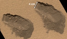
PASADENA, Calif. – NASA’s Mars Curiosity rover has used its full array of instruments to analyze Martian soil for the first time, and found a complex chemistry within the Martian soil. Water and sulfur and chlorine-...
 English
  Français
  العربية