climate_change_0218

Monuments of Science

            On a remote mountaintop, 2600 metres above sea level in the Chilean Atacama Desert, lies the world’s most advanced visible-light observatory. The European Southern Observatory’s Ver...
by Lamouchi Helmi
0


DSC08171

Prof. Mohamed Ayari vists the University of Anbar

Dr. Mohamed AYARI, president of the Tunisian Association of Digital Geographic Information and president of the Euro-Arab of Geomatics, visited on December 24 and 25 2012 the University of Anbar where he discussed with the pres...
by Lamouchi Helmi
0


DSC_0226

Trimble participates in the 7th edition of geotunis

 The international Trimble company, specialized in the production of positioning via satellite devises, surveying techniques and mapping, participated in the 7th edition of geotunis, where it presented its latest techniques in...
by Lamouchi Helmi
0


climate_change_0218

RIEGL launches VZ-6000 Terrestrial Laser Scanner

          RIEGL goes for ultra-long ranges: VZ-6000 offers more than 6,000 m measurement range Horn, Austria, September 24, 2012 – Especially designed for ultra-long range applications in topograp...
by Lamouchi Helmi
0


IMG_9948

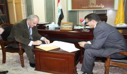
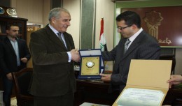
Prof. Mohamed AYARI gets the international scientific shield of the University of Anbar

As a respect of his effort aiming at enhancing the scientific exchange at the Arab and international levels, the president of the University of Anbar, Dr kalil Ibrahim, has granted Prof. Mohamed AYARI, president of the Tunisian...
by Lamouchi Helmi
0


DSC5

Tunisian security institution participates in the activities of the 7th edition of Geotunis

Regarding the importance of geographic information in the improving the security performance, the Tunisian security institution participated in the 7th edition of Geotunis, which was held in Hammamet 8- 12 April 2013. A study d...
by Lamouchi Helmi
0


DSC_0587

5th International Conference on Water Resources and Arid Environments

5th International Conference on Water Resources and Arid Environments 7-9 January 2013 Organizers: Prince Sultan Bin Abdulaziz International Prize for Water (PSIPW) King Saud University, represented by the Prince Sultan Institu...
by Lamouchi Helmi
0


IMG_9983

The Tunisian Association of Digital Geographic Information and the University of Takrit sign a scientific cooperation convention

Within the framework of his visit, Dr. Mohamed AYARI, president of the Tunisian Association of Digital Geographic Information and president of the Euro-Arab Union of Geomatics, paid a visit to the University of Takrit where he ...
by Lamouchi Helmi
0


DSC_0391

7th edition of Geotunis closes its activities and announces its recommendations

The 7th edition of the international congress Geotunis which was opened on April 8 closed its activities on Friday, April 12 2013. The congress gathered the academic, training and investment aspects thanks to the remarkable int...
by Lamouchi Helmi
0