Home
About us
Contact
English
Français
العربية
Home
About us
Evaluation Committee
Publishing Guide
Research
Events
Books and letters
Books
Contact
Sort
Recent
Most Commented
Random
Published Researches
The influences of reduced water evaporation, Gibberellic acid (GA3) on screening lettuce (Lactuca sativa L. var. longifolia cv. Marul) for lowest heading failure, tipburns and bitterness
by Ali Neji
0
Full Review »
Published Researches
SCHEMATIC STUDY OF GROUNDWATER POTENTIAL ZONES IN GRANITIC TERRAIN USING REMOTESENSING AND GIS TECHNIQUES, IN MIYAPUR AND BOLLARAM AREAS OF HYDERABAD, INDIA.
by Ali Neji
0
Full Review »
Published Researches
INVESTIGATION OF SOME HEAVY METALS IN TOW PLANTS OF DRINKING WATER ON BABYLON PROVINCE,IRAQ.
by Ali Neji
0
Full Review »
Published Researches
Determine the morphostructure phenomenon, East Khor Al-Zubair by Space Imageries
Dr.TorhanAlmofti * Ahmed Ibrahim Saleh Al-Naemi** Abstract Through the use of satellite data taken by the Landsat satellites a color phenomenon was...
by Lamouchi Helmi
0
Full Story »
Published Researches
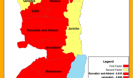
Variations in levels of growth in the provinces of the West Bank using the technique of factor analysis.
by Ali Neji
0
Full Review »
Published Researches
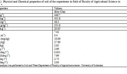
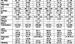
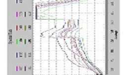
Relationship between Soil Physico-chemical Properties and the Spectral Reflectance’s of Some Soil Sites from Arbil Governorate
by Ali Neji
0
Full Review »
Published Researches
GIS Land use monitoring and its impact on the growth of East Beirut
by Ali Neji
0
Full Review »
Published Researches
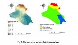
Selecting Suitable Sites for Wind Energy harvesting in Iraq using GIS Techniques
Selecting Suitable Sites for Wind Energy harvesting in Iraq using GIS Techniques WEDYAN G. NASSIF1,2, DALILA ELHMAIDI1 , YASEEN K. Al-TIMIMI2 1 Thermal Radiation Research Unit ,Faculty of Sciences of Tunis ,University o...
by Lamouchi Helmi
0
Full Story »
Published Researches
Using NDVI Algebra to Identify Changes in Had’anya Depression/South Iraq
by Ali Neji
0
Full Review »
Page 6 of 8
« First
‹ Previous
3
4
5
6
7
8
Next ›
The Latest
News
Articles and Interviews
Reporting Geo-sp
Published Researches
International Conference on Social and Human Sciences
Precision Technologies Role in the Study of Climate Change Impact
5th International Conference on Water, Energy, Food and Agricultural Technology Istanbul, Turkey, 22-25 January 2019
Bluesky’s LiDAR experts educate Mouchel’s water industry professionals
Creation of a digital 3-dimensional model
AeroMetric Announces New High Accuracy Mapping Solution
Interview with George Gartner
Measuring earth’s vital magnetic field
Selecting Suitable Sites for Wind Energy harvesting in Iraq using GIS Techniques
Machine Learning and Statically for Evaluating the Classification of Medical and Lab Services
Study the characteristics and nature of the Indian dates tree. Tamarindus Indica L In the southwestern region (Jizan and Asir)
More »
More »
More »
More »
 English
  Français
  العربية