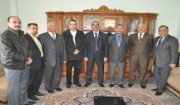
The head of the Desert Research Center at the University of Abnar, Dr. Salah Faiad, granted the center shield to Prof. Mohamed AYARI, President of the Tunisian Association of the Digital Geographic Information, at the Universit...
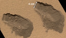
PASADENA, Calif. – NASA’s Mars Curiosity rover has used its full array of instruments to analyze Martian soil for the first time, and found a complex chemistry within the Martian soil. Water and sulfur and chlorine-...
Modeling Ripeness Grading of Palm Oil Fresh Fruit Bunches through Image Processing using Artificial Neural Network Osama M. Ben Saaed1, Meftah Salem M Alfatni1,2*, Abdul Rashid Mohamed Shariff3 and Hadya S Hawedi1 1Faculty of I...
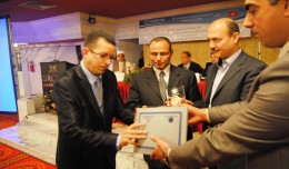
On Monday, April 8, 2013, the Minister of Information Technologies and Communication, Dr Monji Marzouk, in company with governmental stuff and the president of Geotunis, opened the international exhibition of geomatics technolo...
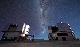
On a remote mountaintop, 2600 metres above sea level in the Chilean Atacama Desert, lies the world’s most advanced visible-light observatory. The European Southern Observatory’s Ver...
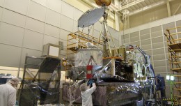
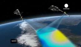
NASA’s Global Precipitation Measurement (GPM) Core Observatory satellite went through its first complete comprehensive performance test (CPT), beginning on Oct. 4, 2012 at NASA’s Goddard ...
5th International Conference on Water Resources and Arid Environments 7-9 January 2013 Organizers: Prince Sultan Bin Abdulaziz International Prize for Water (PSIPW) King Saud University, represented by the Prince Sultan Institu...
The editing committee of GeoSP has interviewed Mr. George Gartner president of ICA and the international academic researcher about the role of ICA in supporting scientific research and young researchers. Mr. Gartner expressed a...
DETECTIONS OF BUILDINGSDIGITAL SURFACE MODELS DEFORMATIONS GENERATED FROM DRONES NADIR IMAGES Jean A. Doumit*, Souhail F. Awad*,Evgeny N. Kiselev** *Lebanese University, Faculty of Letters and Human Sciences, Department of g...
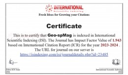
Geo-spMag Journal Achieves Impact Factor of 1.943 in ISI Indexing Geo-spMag Journal Achieves Impact Factor of 1.943 in ISI Indexing In a significant milestone for Arab scientific publishing, the international peer-reviewed jour...
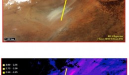
Summary: This past spring and summer, NASA DEVELOPstudent interns used NASA’s Earth Observing System to examine spectral characteristics of dust storms in the Middle East. The results of this study aided project partners by ...
 English
  Français
  العربية