Modeling Ripeness Grading of Palm Oil Fresh Fruit Bunches through Image Processing using Artificial Neural Network Osama M. Ben Saaed1, Meftah Salem M Alfatni1,2*, Abdul Rashid Mohamed Shariff3 and Hadya S Hawedi1 1Faculty of I...
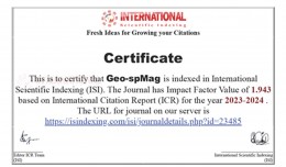
Geo-spMag Journal Achieves Impact Factor of 1.943 in ISI Indexing Geo-spMag Journal Achieves Impact Factor of 1.943 in ISI Indexing In a significant milestone for Arab scientific publishing, the international peer-reviewed jour...
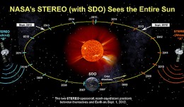
On Nov. 20, 2012, at 7:09 a.m. EST, the sun erupted with a coronal mass ejection or CME. Not to be confused with a solar flare, a CME is a solar phenomenon that can send solar particles into space and can reach Earth one to thr...
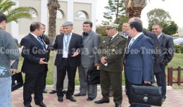
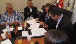
Regarding the importance of geographic information in the improving the security performance, the Tunisian security institution participated in the 7th edition of Geotunis, which was held in Hammamet 8- 12 April 2013. A study d...
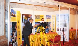
The international Trimble company, specialized in the production of positioning via satellite devises, surveying techniques and mapping, participated in the 7th edition of geotunis, where it presented its latest techniques in...
The editing committee of GeoSP has interviewed Mr. George Gartner president of ICA and the international academic researcher about the role of ICA in supporting scientific research and young researchers. Mr. Gartner expressed a...
Bouzayani Rajab [1]/ Abida Zouheir[2] [1] Bouzayani Rajab : Faculty of Economics and Management of Sfax, University of Sfax – Tunisia. E-mail: bouzayanilazher@gmail.com [2] Abida Zouheir : Faculty of Economics and Mana...
On Monday, April 8, 2013, the Minister of Information Technologies and Communication, Dr Monji Marzouk, in company with governmental stuff and the president of Geotunis, opened the international exhibition of geomatics technolo...
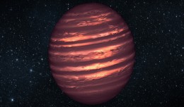
PASADENA, Calif. — Astronomers using NASA’s Spitzer and Hubble space telescopes have probed the stormy atmosphere of a brown dwarf, creating the most detailed “weather map” yet for this class of cool, st...
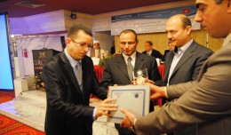
A collaboration protocol was signed on Wednesday morning May 15,2013 inthe Euro-Arab Union of geomatics office inBeirut,Lebanon. The protocol states the technical and scientific cooperation between academics and professionals i...
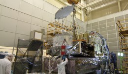
NASA’s Global Precipitation Measurement (GPM) Core Observatory satellite went through its first complete comprehensive performance test (CPT), beginning on Oct. 4, 2012 at NASA’s Goddard ...
 English
  Français
  العربية