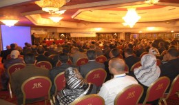
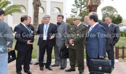
Arab and African participation in the 7th edition of Geotunis held between April 8-12 2013 in the Royal Resort hotel, Hammamet in the presence of experts, specialists, scientists, representatives of ministries, companies and pe...
Regarding the importance of geographic information in the improving the security performance, the Tunisian security institution participated in the 7th edition of Geotunis, which was held in Hammamet 8- 12 April 2013. A study d...
Drone base multiscale Digital Surface Models to planar areas. Dr. Jean A. Doumit Abstract The obtaining of a Digital Surface models (DSMs) at different scales and levels before the appearance of Unmanned Aerial Vehicles (UAV...
Bouzayani Rajab [1]/ Abida Zouheir[2] [1] Bouzayani Rajab : Faculty of Economics and Management of Sfax, University of Sfax – Tunisia. E-mail: bouzayanilazher@gmail.com [2] Abida Zouheir : Faculty of Economics and Mana...
Although the ultimate goal of the PhoneSat mission was to determine whether a consumer-grade smartphone can be used as the main flight avionics for a satellite in space, the three miniature satellites (named Alexander, Graham a...
Suliman Emdini Gliwan*1 Kevin Crowe *2 *1Ph.D.Candidate, Faculty of Natural Resource Management, Lakehead University, 955 Oliver Rd, Thunder Bay, ON, Canada (P7B5E1). *2Associate Professor, Faculty of Natural Resource Managemen...
The Faculty of Earth Sciences Geography and Spatial Configuration, University of Wahran, organized the 4th edition of Algerian Geographic Days on 11/12 December 2012. A number of academics, researchers, and amateurs in the fi...
Information Technology Infrastructure Library ITIL Oldo-lina Foundation for the French East development in collaboration with the Euro-Arab union Geomatics organizes training for IT Service Management ITIL V3 Will be held in Ly...
The head of the Desert Research Center at the University of Abnar, Dr. Salah Faiad, granted the center shield to Prof. Mohamed AYARI, President of the Tunisian Association of the Digital Geographic Information, at the Universit...
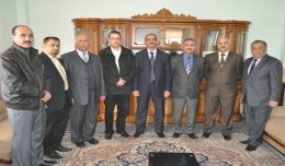
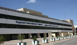
Dr. Mohamed AYARI, President of the Tunisian Association of Digital Geographic Information and President of the EuroArab Union of Geomatics, visited the Iraqi Republic from December 22 to December 30 2012. During this visit he ...
 English
  Français
  العربية